Wade, Oklahoma | |
|---|---|
 Wade, Oklahoma | |
| Coordinates: 33°53′20″N 96°04′34″W / 33.88889°N 96.07611°W | |
| Country | United States |
| State | Oklahoma |
| County | Bryan |
| Elevation | 528 ft (161 m) |
| Time zone | UTC-6 (Central (CST)) |
| • Summer (DST) | UTC-5 (CDT) |
| Area code | Area code 580 |
| GNIS feature ID | 1099282[1] |
Wade is an unincorporated community in Bryan County, Oklahoma, United States.[1] The community is located on Oklahoma State Highway 70E, 11 miles (18 km) south of Bokchito. Wade had a post office from October 24, 1890, to November 30, 1971. The community was named for Choctaw Alfred Wade.[2]
References
- 1 2 "Wade". Geographic Names Information System. United States Geological Survey, United States Department of the Interior.
- ↑ Shirk, George H. (1974). Oklahoma Place Names (2 ed.). Norman, Oklahoma: University of Oklahoma Press. p. 53. ISBN 0806111402.
Municipalities and communities of Bryan County, Oklahoma, United States | ||
|---|---|---|
| City | 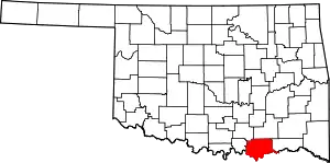 Bryan County map | |
| Towns | ||
| CDPs | ||
| Other communities | ||
| Ghost towns | ||
| Indian reservations | ||
| Footnotes | ‡This populated place also has portions in an adjacent county or counties | |
This article is issued from Wikipedia. The text is licensed under Creative Commons - Attribution - Sharealike. Additional terms may apply for the media files.