Wambrechies
Wemmersijs | |
|---|---|
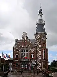 The town hall in Wambrechies | |
.svg.png.webp) Coat of arms | |
Location of Wambrechies | |
 Wambrechies  Wambrechies | |
| Coordinates: 50°41′10″N 3°02′58″E / 50.6861°N 3.0494°E | |
| Country | France |
| Region | Hauts-de-France |
| Department | Nord |
| Arrondissement | Lille |
| Canton | Lille-1 |
| Intercommunality | Métropole Européenne de Lille |
| Government | |
| • Mayor (2020–2026) | Sébastien Brogniart[1] |
| Area 1 | 16 km2 (6 sq mi) |
| Population | 10,798 |
| • Density | 670/km2 (1,700/sq mi) |
| Time zone | UTC+01:00 (CET) |
| • Summer (DST) | UTC+02:00 (CEST) |
| INSEE/Postal code | 59636 /59118 |
| Elevation | 13–26 m (43–85 ft) (avg. 20 m or 66 ft) |
| 1 French Land Register data, which excludes lakes, ponds, glaciers > 1 km2 (0.386 sq mi or 247 acres) and river estuaries. | |
Wambrechies (French pronunciation: [wɑ̃bʁəʃi]; West Flemish: Wemmersijs; Picard: Vamberchi) is a commune in the Nord department, in the region Hauts-de-France, in northern France. It is part of the European Metropolis of Lille.[3] It has a population of around 10,600 (2019).
Geography
Wambrechies is situated to the north of Lille, it is bordered by the neighbouring communes of Marquette-lez-Lille (to the southeast), Saint André-lez-Lille (to the south), Quesnoy-sur-Deûle (to the northwest) and Bondues (to the northeast). The Deûle canal runs from north to south through the town.
Heraldry
Arms of Wambrechies |
The arms of Wambrechies are blazoned : Or, a cross engrailed gules. (Artres, Bettrechies, Cerfontaine, Denain, Eth, Lesquin, Obies, Quérénaing, Semousies, Wambrechies and Warlaing use the same arms.)
|
Population
| Year | Pop. | ±% p.a. |
|---|---|---|
| 1968 | 5,845 | — |
| 1975 | 7,894 | +4.39% |
| 1982 | 8,152 | +0.46% |
| 1990 | 8,250 | +0.15% |
| 1999 | 8,552 | +0.40% |
| 2007 | 9,875 | +1.81% |
| 2012 | 9,665 | −0.43% |
| 2017 | 10,948 | +2.52% |
| Source: INSEE[4] | ||
Twin towns
Kempen, Germany since 1972.
See also
References
- ↑ "Répertoire national des élus: les maires" (in French). data.gouv.fr, Plateforme ouverte des données publiques françaises. 13 September 2022.
- ↑ "Populations légales 2021". The National Institute of Statistics and Economic Studies. 28 December 2023.
- ↑ INSEE commune file
- ↑ Population en historique depuis 1968, INSEE