Černíkovice | |
|---|---|
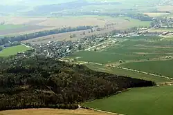 Aerial view | |
.svg.png.webp) Flag  Coat of arms | |
 Černíkovice Location in the Czech Republic | |
| Coordinates: 50°11′12″N 16°12′25″E / 50.18667°N 16.20694°E | |
| Country | |
| Region | Hradec Králové |
| District | Rychnov nad Kněžnou |
| First mentioned | 1369 |
| Area | |
| • Total | 12.50 km2 (4.83 sq mi) |
| Elevation | 316 m (1,037 ft) |
| Population (2023-01-01)[1] | |
| • Total | 819 |
| • Density | 66/km2 (170/sq mi) |
| Time zone | UTC+1 (CET) |
| • Summer (DST) | UTC+2 (CEST) |
| Postal codes | 516 01, 517 04 |
| Website | www |
Černíkovice is a municipality and village in Rychnov nad Kněžnou District in the Hradec Králové Region of the Czech Republic. It has about 800 inhabitants.
Administrative parts

Černíkovice over the Černíkovický pond
The village of Domašín is an administrative part of Černíkovice.
Geography
Černíkovice is located about 5 kilometres (3 mi) northwest of Rychnov nad Kněžnou and 26 km (16 mi) east of Hradec Králové. It lies in the Orlice Table. The highest point of the municipality is the hill Na Hraběnce with an altitude of 358 metres (1,175 ft). There are four ponds in the municipal territory, the largest of them is Černíkovický.
References
External links
Wikimedia Commons has media related to Černíkovice (Rychnov nad Kněžnou District).
This article is issued from Wikipedia. The text is licensed under Creative Commons - Attribution - Sharealike. Additional terms may apply for the media files.