Zdobnice | |
|---|---|
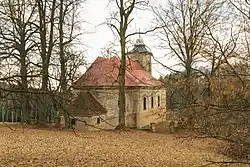
 Church of Saint Catherine | |
 Coat of arms | |
 Zdobnice Location in the Czech Republic | |
| Coordinates: 50°14′19″N 16°24′31″E / 50.23861°N 16.40861°E | |
| Country | |
| Region | Hradec Králové |
| District | Rychnov nad Kněžnou |
| First mentioned | 1550 |
| Area | |
| • Total | 33.04 km2 (12.76 sq mi) |
| Elevation | 605 m (1,985 ft) |
| Population (2023-01-01)[1] | |
| • Total | 169 |
| • Density | 5.1/km2 (13/sq mi) |
| Time zone | UTC+1 (CET) |
| • Summer (DST) | UTC+2 (CEST) |
| Postal code | 516 01 |
| Website | www |
Zdobnice (German: Stiebnitz) is a municipality and village in Rychnov nad Kněžnou District in the Hradec Králové Region of the Czech Republic. It has about 200 inhabitants. The hamlet of Kačerov within the municipality is well preserved and is protected by law as a village monument zone.
Geography
Zdobnice is located about 12 kilometres (7 mi) northeast of Rychnov nad Kněžnou and 40 km (25 mi) east of Hradec Králové. It lies in the Orlické Mountains. The highest point is the mountain Tetřevec at 1,044 metres (3,425 ft) above sea level. The Zdobnice River flows through the municipality.
Sport
Zdobnice is a small ski resort with three ski lifts.[2]
References
- ↑ "Population of Municipalities – 1 January 2023". Czech Statistical Office. 2023-05-23.
- ↑ "Vítá vás horská obec Zdobnice" (in Czech). Obec Zdobnice. Retrieved 2022-09-02.
Wikimedia Commons has media related to Zdobnice.
This article is issued from Wikipedia. The text is licensed under Creative Commons - Attribution - Sharealike. Additional terms may apply for the media files.