 | |
|---|---|
| Autobunn 7 | |
| Autoroute du Nord | |
 | |
 | |
| Route information | |
| Length | 31.468 km (19.553 mi) |
| Existed | 10 November 1989–present |
| History | Completed 23 September 2015 |
| Major junctions | |
| South end | Kirchberg for Luxembourg City, A1 |
| Heisdorf Lorentzweiler Mersch Colmar-Berg Schieren Ettelbruck Erpeldange | |
| North end | Clervaux |
| Location | |
| Country | Luxembourg |
| Highway system | |
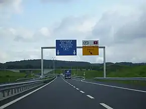
The A7 or otherwise known as the North motorway (French: Autoroute du Nord, Luxembourgish: Nordstroos), is a motorway in Luxembourg. It links the capital city with the North of the country
Status
The entire A7 opened on 23 September 2015 at 8 P.M.[1] The complete motorway is 31.468 km long.
All of the eight planned sections of the A7 are in service:
- 10 November 1989: Ettelbruck – Erpeldange
- 29 July 1993: Schieren – Ettelbruck
- August 1996: Erpeldange – Fridhaff
- 16 November 2001: Schoenfels – Mierscherbierg
- 16 November 2001: Mierschbierg – Schieren
- 13 September 2002: Grunewald – Waldhof
- 24 January 2008: Lorentzweiler – Schoenfels[2]
- 23 September 2015: Waldhof – Lorentzweiler
Route
| Junctions and structures | ||
| Clervaux | ||
| Erpeldange | ||
| Ingeldorf | ||
| Ettelbruck | ||
| Schieren | ||
| Colmar-Berg | ||
| Mierscherberg | ||
| Mersch | ||
| Mersch Tunnel | ||
| Schoenfels | ||
| Gousselerbierg Tunnel | ||
| Lorentzweiler | ||
| Grouft Tunnel | ||
| Stafelter Tunnel | ||
| Waldhof | ||
| Grunewald Junction | ||
References
- ↑ "La Nordstrooss mise en service le 23 septembre" (in French).
- ↑ "Evolution du réseau autoroutier" (in French). Administration des Ponts et Chaussées. 24 January 2008. Archived from the original on 3 March 2009. Retrieved 29 December 2008.
External links
![]() Media related to A7 (Luxembourg) at Wikimedia Commons
Media related to A7 (Luxembourg) at Wikimedia Commons
This article is issued from Wikipedia. The text is licensed under Creative Commons - Attribution - Sharealike. Additional terms may apply for the media files.