Augusta metropolitan area | |
|---|---|
| Augusta-Richmond County, GA-SC metropolitan statistical area | |
 Downtown Augusta | |
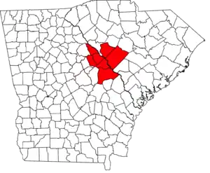 Map of the Augusta-Richmond County MSA | |
| Country | |
| State | |
| Largest city | Augusta |
| Area | |
| • Total | 4,045 sq mi (10,480 km2) |
| • Land | 3,932 sq mi (10,180 km2) |
| • Water | 113 sq mi (290 km2) 2.8% |
| Population (2021) | |
| • Total | 615,963 (est.)[1][2] |
| • Rank | 96th[3] |
| Time zone | UTC-5 (EST) |
| • Summer (DST) | UTC-4 (EDT) |
| Area codes | 478, 706, 762, 803, 839, 864 |
The Augusta metropolitan area is a metropolitan area in the U.S. states of Georgia and South Carolina centered on the principal city of Augusta. The U.S. Office of Management and Budget, Census Bureau and other agencies define Augusta's metropolitan statistical area, the Augusta-Richmond County, GA-SC metropolitan statistical area, as comprising Richmond, Burke, Columbia, Lincoln, and McDuffie counties in Georgia and Aiken and Edgefield counties in South Carolina. The official 2021 U.S. census estimate for the area was 615,963 residents.[1][2]
Geography
The Augusta metropolitan area consists of seven counties: five in Georgia, and two in South Carolina. Among the counties making up the metropolitan region, Richmond, Aiken, and Columbia were its most populous. Making up more than 4,045 sq mi (10,480 square kilometers) in total area, the MSA would be larger than Delaware if it were a U.S. state.
Georgia metropolitan counties
| County | Population (2020) |
|---|---|
| Richmond County | 206,607 |
| Columbia County | 156,010 |
| Burke County | 24,596 |
| McDuffie County | 21,632 |
| Lincoln County | 7,690 |
| Total: | 416,535 |
South Carolina metropolitan counties
| County | Population (2020) |
|---|---|
| Aiken County | 168,808 |
| Edgefield County | 25,657 |
| Total: | 194,465 |
Communities
Places with more than 100,000 inhabitants
- Augusta-Richmond County (balance), Georgia (principal city) Pop: 197,872
Places with 10,000 to 40,000 inhabitants
- Martinez, Georgia Pop: 35,795
- Aiken, South Carolina Pop: 29,884
- Evans, Georgia Pop: 29,011
- North Augusta, South Carolina Pop: 21,873
- Grovetown, Georgia Pop: 14,473
Places with 5,000 to 10,000 inhabitants
- Thomson, Georgia Pop: 6,718
- Belvedere, South Carolina Pop: 5,792
- Waynesboro, Georgia Pop: 5,816
Places with 1,000 to 5,000 inhabitants
- Edgefield, South Carolina Pop: 4,690
- Barnwell, South Carolina Pop: 4,500
- Clearwater, South Carolina Pop: 4,370
- Hephzibah, Georgia Pop: 4,021
- Gloverville, South Carolina Pop: 2,831
- Burnettown, South Carolina Pop: 2,673
- Harlem, Georgia Pop: 2,779
- Johnston, South Carolina Pop: 2,362
- New Ellenton, South Carolina Pop: 2,052
- Jackson, South Carolina Pop: 1,700
- Lincolnton, Georgia Pop: 1,520
Places with fewer than 1,000 inhabitants
- Sardis, Georgia Pop: 995
- Wagener, South Carolina Pop: 631
- Blythe, Georgia Pop: 744
- Dearing, Georgia Pop: 529
- Salley, South Carolina Pop: 329
- Keysville, Georgia (partial) Pop: 300
- Midville, Georgia Pop: 385
- Monetta, South Carolina (partial) Pop: 205
- Perry, South Carolina Pop: 194
- Trenton, South Carolina Pop: 200
- Girard, Georgia Pop: 184
- Windsor, South Carolina Pop: 115
- Vidette, Georgia Pop: 103
Demographics
According to the 2000 U.S. census, there were 499,684 people, 184,801 households, and 132,165 families residing within the MSA.[4] By the 2020 census, its population was 611,000, with a 2021 estimated population of 615,963 per the American Community Survey. A year later, it had an estimated metropolitan population of 622,829.[5]
In 2000, the racial makeup of the MSA was 60.81% White, 35.09% African American, 0.32% Native American, 1.42% Asian, 0.08% Pacific Islander, 0.85% from other races, and 1.43% from two or more races. Hispanic or Latinos of any race were 2.40% of the population. According to the 2022 American Community Survey,[5] its racial and ethnic makeup was 52% White, 34% African American, 2% Asian, 1% other, 4% multiracial, and 6% Hispanic or Latino of any race.
In 2000, the median income for a household in the MSA was $36,933, and the median income for a family was $42,869. Males had a median income of $34,574 versus $22,791 for females. The per capita income for the MSA was $17,652. In 2022, the estimated median household income was $64,851 with a per capita income of $34,401. Of its population, 40% earned less than $50,000 annually; 29% earned from $50,000 to $100,000 annually; 23% $100,000 to $200,000; and 8% earned more than $200,000 annually.[5] Among the population, approximately 15% lived at or below the poverty line.
Economy
The largest metropolitan industries are medicine, biotechnology, cyber security, manufacturing, and education. Prominent employers and organizations throughout the region have been Augusta University, Augusta Technical College, Paine College, East Georgia State College and Georgia Military College, the Richmond County School System, Savannah River Site,[6] Encompass Health Corporation,[7] T-Mobile, Teleperformance, and Coca-Cola.[8] Among the colleges and universities, Augusta University has made an economic impact of $2.24 billion and more than 21,000 jobs to the state's economy as of 2022.[9]
Transportation
Airports
Interstates and other highways
 I-20 (Carl Sanders Highway)
 I-520 (Bobby Jones Expressway / Deputy James D. Paugh Memorial Highway)
 US 1 (Deans Bridge Road (from Jefferson County line to Gordon Highway); Gordon Highway (from Deans Bridge Road to South Carolina state line); Fall Line Freeway (from Jefferson County line to I-520))
 US 25 (Peach Orchard Road (entire length); Gordon Highway (from Peach Orchard Road to South Carolina state line))
 US 25 Bus. (Broad Street / 13th Street)
 US 78 / US 278 (Gordon Highway)
 SR 4 (follows US 1 from Jefferson County line to Gordon Highway; leaves Georgia at James U. Jackson Memorial Bridge)
 SR 28 (various roads, including John C. Calhoun Expressway and Washington Road)
 SR 56 (Mike Padgett Highway)
 SR 88 in southern Richmond County
 SR 104 (Washington Road; Pleasant Home Road; River Watch Parkway)
 SR 104 Conn. (Washington Road)
 SR 232 (Columbia Road / Bobby Jones Expressway)
 SR 383 (Jimmie Dyess Parkway)
 SR 540 (Fall Line Freeway (Deans Bridge Road from Jefferson County line to I-520))[10]
 SR 555 / SR 565 (Savannah River Parkway (Peach Orchard Road from Burke County line to I-520))
See also
References
- 1 2 "Metropolitan and Micropolitan Statistical Areas Population Totals and Components of Change: 2010-2019". United States Census Bureau, Population Division. April 2019. Retrieved April 18, 2020.
- 1 2 "Metropolitan and Micropolitan Statistical Areas Population Totals and Components of Change: 2010-2019". United States Census Bureau, Population Division. March 26, 2020. Retrieved April 26, 2020.
- ↑ "Table 1. Annual Estimates of the Population of Metropolitan and Micropolitan Statistical Areas: April 1, 2010 to July 1, 2012". 2012 Population Estimates. United States Census Bureau, Population Division. March 2013. Archived from the original (CSV) on 2013-04-01. Retrieved 2013-06-05.
- ↑ "U.S. Census website". United States Census Bureau. Retrieved 2008-01-31.
- 1 2 3 "Census profile: Augusta-Richmond County, GA-SC Metro Area". Census Reporter. Retrieved 2024-01-05.
- ↑ "SRS - Where We Are". Savannah River Site. Retrieved 2024-01-05.
- ↑ "Inpatient Rehabilitation Hospital Augusta". Walton Rehabilitation Hospital, an affiliate of Encompass Health. Retrieved 2024-01-05.
- ↑ "Augusta". Coca-Cola UNITED. Retrieved 2024-01-05.
- ↑ Austin, Milledge (2022-06-29). "Augusta University adds $2.24 billion, over 21,000 jobs to Georgia economy". Jagwire. Retrieved 2024-01-05.
- ↑ "Fall Line Freeway" (PDF). Archived from the original (PDF) on June 4, 2011. Retrieved April 9, 2011.