| Bald Point State Park | |
|---|---|
IUCN category IV (habitat/species management area) | |
 Overlooking Chaires Creek | |
  | |
| Location | Franklin County, Florida, USA |
| Nearest city | Alligator Point, Florida |
| Coordinates | 29°56′51″N 84°20′29″W / 29.94750°N 84.34139°W |
| Governing body | Florida Department of Environmental Protection |
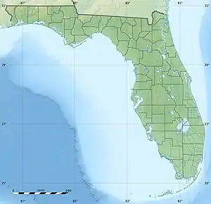
Bald Point State Park is a Florida State Park located south of Ochlockonee Bay, approximately seven miles southeast of Panacea, on St. James Island in Alligator Point, Tallahassee's closest beach, off U.S. 98, in Franklin County northwestern Florida. The address is 146 Box Cut. Park was named after Bald Point cape on eastern tip of St. James Island in Ochlockonee Bay.[1]
The first land in Bald Point State Park, 1,349 acres (5.46 km2) primarily along the shore of Apalachee Bay, was purchased by the state in 1999.[2] A major expansion of the park occurred in 2002 when Florida purchased 2,851 acres (11.54 km2) of land from St. Joe Company for $10.3 million. The purchased land was on Ochlockonee Bay, east of the Crooked River (Florida) in Franklin County, Florida.[3] As of 2006, the park included approximately 4,860 acres (19.7 km2).[2]
Recreational Activities
The park has such amenities as beaches, bicycling, birding, canoeing, fishing, hiking, kayaking, swimming and wildlife viewing.
Gallery
References
- ↑ "Bald Point, Florida". Geographic Names Information System. United States Geological Survey, United States Department of the Interior.
- 1 2 Bald Point State Park Approved Management Plan (PDF) (Report). Florida Department of Environmental Protection. April 21, 2006. pp. 1, A 1-1. Retrieved September 23, 2021.
- ↑ "State buys 13,000 acres along river". Tampa Bay Times. September 2, 2005. Retrieved September 23, 2021.
External links
- Bald Point State Park at Florida State Parks
- Bald Point State Park at Visit Florida
- Nature Tourism - Bald Point State Park - State Extension Service site


