Betroka District | |
|---|---|
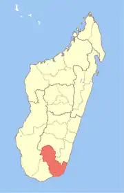
 Betroka District Location in Madagascar | |
| Coordinates: 23°16′6″S 46°06′16″E / 23.26833°S 46.10444°E | |
| Country | |
| Region | Anosy |
| District | Betroka |
| Area | |
| • Total | 14,060 km2 (5,430 sq mi) |
| Population (2018)census | |
| • Total | 210,071 |
| • Ethnicities | Bara |
| Time zone | UTC3 (EAT) |
| Postal code | 613 |
Betroka is a district of Anosy in Madagascar.[1][2]
Communes
The district is further divided into 20 communes:
- Ambalasoa
- Ambatomivary
- Analamary
- Andriandampy
- Beapombo I
- Beapombo II
- Bekorobo
- Benato-Toby
- Betroka
- Iaborotra
- Ianabinda
- Ianakafy
- Isoanala
- Ivahona
- Jangany
- Mahabo
- Mahasoa Est
- Nagnarena
- Naninora
- Tsaraitso
Rivers
The Mangoky River and its affluents (Imaloto, Sakamahily, Sakory, Ihazototsy) is the main river system in the district of Betroka.
References
- ↑ REPOBLIKAN’I MADAGASIKARA:Tanindrazana – Fahafahana – Fandrosoana (PDF). MINISTERE DE L’AGRICULTURE, DE L’ELEVAGE ET DE LA PECHE. October 2007. pp. 42–44. Archived from the original (PDF) on 2018-06-12. Retrieved 2018-06-09.
- ↑ "Madagascar: Administrative Division". citypopulation. Retrieved 10 June 2018.
Capital: Fort Dauphin (Taolagnaro) | ||
| Amboasary Sud (18) - 603 |
|  |
| Betroka (20) - 613 | ||
| Taolagnaro (24) - 614 | ||
3 districts; 62 communes | ||
This article is issued from Wikipedia. The text is licensed under Creative Commons - Attribution - Sharealike. Additional terms may apply for the media files.