Bowers, Pennsylvania | |
|---|---|
 Bowers  Bowers | |
| Coordinates: 40°29′14″N 75°44′32″W / 40.48722°N 75.74222°W | |
| Country | United States |
| State | Pennsylvania |
| County | Berks |
| Township | Maxatawny |
| Area | |
| • Total | 0.61 sq mi (1.58 km2) |
| • Land | 0.61 sq mi (1.57 km2) |
| • Water | 0.00 sq mi (0.00 km2) |
| Elevation | 449 ft (137 m) |
| Population | |
| • Total | 355 |
| • Density | 583.88/sq mi (225.53/km2) |
| Time zone | UTC-5 (Eastern (EST)) |
| • Summer (DST) | UTC-4 (EDT) |
| ZIP Codes | 19511 & 19539 |
| Area code(s) | 610 & 484 |
| FIPS code | 42-07800 |
| GNIS feature ID | 1170048[3] |
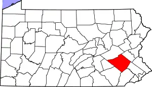
Bowers is a census-designated place[4] in Maxatawny Township, Berks County, Pennsylvania.
Bowers is located near the borough of Lyons and is on Sacony Creek, a tributary of the Maiden Creek. As of the 2010 census, the population was 326 residents.[5] Although Bowers has its own post office with the ZIP code of 19511, some residents are served by the Mertztown post office with the ZIP code of 19539.
| Census | Pop. | Note | %± |
|---|---|---|---|
| 2020 | 355 | — | |
| U.S. Decennial Census[6][2] | |||
History
Bowers was founded in 1860, the same year the railroad was extended to Bowers. The community was named for the local Bower family.[7]
References
- ↑ "ArcGIS REST Services Directory". United States Census Bureau. Retrieved October 12, 2022.
- 1 2 "Census Population API". United States Census Bureau. Retrieved October 12, 2022.
- ↑ "Bowers". Geographic Names Information System. United States Geological Survey, United States Department of the Interior.
- ↑ "2010 Census". Archived from the original on December 23, 2013. Retrieved May 25, 2015.
- ↑ https://www.census.gov/#
- ↑ "Census of Population and Housing". Census.gov. Retrieved June 4, 2016.
- ↑ "Some peculiar post office names in Berks". Reading Eagle. November 27, 1910. p. 11. Retrieved December 2, 2015.
This article is issued from Wikipedia. The text is licensed under Creative Commons - Attribution - Sharealike. Additional terms may apply for the media files.
