Bušanovice | |
|---|---|
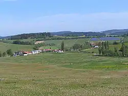 View from the south | |
 Flag  Coat of arms | |
 Bušanovice Location in the Czech Republic | |
| Coordinates: 49°6′56″N 13°56′5″E / 49.11556°N 13.93472°E | |
| Country | |
| Region | South Bohemian |
| District | Prachatice |
| First mentioned | 1314 |
| Area | |
| • Total | 9.73 km2 (3.76 sq mi) |
| Elevation | 540 m (1,770 ft) |
| Population (2023-01-01)[1] | |
| • Total | 262 |
| • Density | 27/km2 (70/sq mi) |
| Time zone | UTC+1 (CET) |
| • Summer (DST) | UTC+2 (CEST) |
| Postal code | 384 22 |
| Website | www |
Bušanovice is a municipality and village in Prachatice District in the South Bohemian Region of the Czech Republic. It has about 300 inhabitants.
Administrative parts
Villages of Beneda, Dolní Nakvasovice, Horní Nakvasovice and Želibořice are administrative parts of Bušanovice.
Geography
Bušanovice is located about 12 kilometres (7 mi) north of Prachatice and 42 km (26 mi) northwest of České Budějovice. It lies in the Bohemian Forest Foothills. The highest point is the hill Uhřice at 822 metres (2,697 ft).
History
The first written mention of Bušanovice is from 1314. It was founded as one of the old free royal settlements in the area. In 1490 it was first listed as part of the Hluboká estate. In 1552, it was acquired by William of Rosenberg.[2]
Sights
The main landmark of Bušanovice is the Chapel of the Virgin Mary from the second half of the 18th century.[3]
Notable people
- Jakub Bursa (1813–1884), architect
References
- ↑ "Population of Municipalities – 1 January 2023". Czech Statistical Office. 2023-05-23.
- ↑ "O obci: Historie obce" (in Czech). Obec Bušanovice. Retrieved 2021-08-24.
- ↑ "Kaple Panny Marie" (in Czech). National Heritage Institute. Retrieved 2023-06-23.