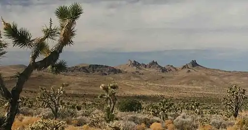
| Castle Mountains National Monument | |
|---|---|
 Castle Peaks (Mojave National Preserve) as seen from Castle Mountains National Monument | |
  | |
| Location | San Bernardino County, California |
| Coordinates | 35°15′N 115°07′W / 35.25°N 115.11°W |
| Area | 20,920 acres (8,470 ha) |
| Authorized | February 12, 2016 |
| Governing body | National Park Service |
| Website | Castle Mountains National Monument |

Castle Mountains National Monument is a U.S. National Monument located in the eastern Mojave Desert and northeastern San Bernardino County, in the state of California.[1][2][3]
The park protects 20,920 acres, located between the interstates I−15 and I−40, and northwest of the Colorado River.
Geography
The national monument protects a section of the Castle Mountains, a range located in San Bernardino County and Clark County, Nevada. The range lies south and east of the New York Mountains, southwest of Searchlight and west of Cal-Nev-Ari, Nevada. The range lies at the northeastern end of Lanfair Valley and reaches 5,543 feet (1,690 m) in elevation at the summit of Hart Peak and 5580 ft at Linder Peak. The mountains lie in a southwest-northeasterly direction. The Piute Range lies to the southeast.[4]
Castle Mountains National Monument is surrounded on three sides by the Mojave National Preserve, managed by the National Park Service.
It surrounds the Castle Mountain Mine Area, an open pit gold mine in the southern Castle Mountains owned by Canadian NewCastle Gold Ltd., who can excavate nearly 10 million tons of ore through 2025, though due to low gold prices mining has been suspended since 2001.[2][5] The national monument proclamation states that after any such mining and reclamation are completed, or after 10 years if no mining occurs, the Federal land in the 8,340 acre Castle Mountain Mine Area is to be transferred to the National Park Service.[5]
Designation and management
It was designated by President Obama on February 12, 2016, along with Mojave Trails National Monument and Sand to Snow National Monument also in Southern California.[1] [6] Of the three it is the only one to be managed by the National Park Service, with the other two being placed under the control of the Bureau of Land Management and/or the United States Forest Service.[7][8][9][10][11]
See also
- List of national monuments of the United States
- Natural history of the Mojave Desert
- Protected areas of the Mojave Desert
- Mojave National Preserve topics
References
- 1 2 Whitehouse.gov: Presidential Proclamation − Establishment of the Castle Mountains National Monument, February 12, 2016.
- 1 2 Los Angeles Times: "Volcanic spires and Joshua trees: Obama protects 1.8 million acres in California's desert", February 11, 2016, by Louis Sahagun; accessed February 14, 2016.
- ↑ Campaign for the California Desert.org: Fact sheet for Castle Mountains National Monument
- ↑ Sahagun, Louis (February 11, 2016). "Obama creates 3 new national monuments to protect 1.8 million acres of California desert". Los Angeles Times. Retrieved 2016-02-12.
- 1 2 Marketwired.com: "NewCastle's Gold Project not included in New Castle Mountain Monument" . accessed February 14, 2016.
- ↑ Eilperin, Juliet (February 12, 2016). "With 3 new monuments, Obama creates world's second-largest desert preserve". The Washington Post. Retrieved 14 February 2016.
- ↑ Whitehouse.gov: Presidential Proclamation − Establishment of the Mojave Trails National Monument, February 12, 2016 — "The Secretary of the Interior shall manage the monument through the Bureau of Land Management (BLM) as a unit of the National Landscape Conservation System
- ↑ BLM California: Mojave Trails National Monument website Archived 2016-02-16 at the Wayback Machine
- ↑ Whitehouse.gov: Presidential Proclamation − Establishment of the Sand to Snow National Monument, February 12, 2016 — "The USFS shall manage that portion of the monument within the boundaries of the San Bernardino National Forest, and BLM shall manage the remainder of the monument."
- ↑ BLM California: Sand to Snow National Monument website (83,000 acres)
- ↑ USDA Forest Service: Sand to Snow National Monument webpage (71,000 acres).