Central West End | |
|---|---|
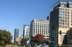 Skyline of the Central West end as seen from Forest Park. The building on the far left is One Hundred Above the Park and the buildings on the right are a part of the Barnes-Jewish Hospital complex. | |
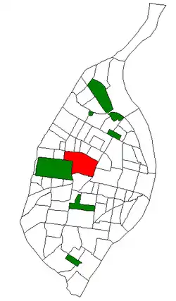 Location (red) of the Central West End within St. Louis | |
| Country | United States |
| State | Missouri |
| City | St. Louis |
| Wards | 17, 18, 28 |
| Area | |
| • Total | 1.89 sq mi (4.9 km2) |
| Population (2020)[1] | |
| • Total | 16,670 |
| • Density | 8,800/sq mi (3,400/km2) |
| ZIP code(s) | Parts of 63108 63110 |
| Area code(s) | 314 |
| Website | stlouis-mo.gov |
The Central West End is a neighborhood in St. Louis, Missouri, stretching from Midtown's western edge to Union Boulevard and bordering on Forest Park with its outstanding array of free cultural institutions. It includes the Cathedral Basilica of Saint Louis (the New Cathedral) on Lindell Boulevard at Newstead Avenue, which houses the largest collection of mosaics in the world. The Central West End sits entirely within the 9th Ward.[2]
Notable people
Playwright Tennessee Williams grew up in the neighborhood, and the house of the renowned poet T. S. Eliot is located in the Central West End. Beat writer William S. Burroughs's childhood home sits on Pershing Avenue (formerly Berlin Avenue) in the neighborhood. And though often mistaken as the location of Sally Benson's home, the setting of the stories which were adapted into the movie Meet Me in St. Louis, 5135 Kensington Avenue was actually located in the Academy neighborhood just across Delmar Boulevard to the north.
George Julian Zolnay (Gyula Zsolnay) (July 4, 1863 – May 1, 1949) the Hungarian and American sculptor known as the "Sculptor of the Confederacy" lived in the Central West End in the early 1900s at 4384 Maryland Avenue.[3]
Geography

The neighborhood's boundaries are Union Boulevard and the eastern portion of Forest Park on the west, I-64/US 40 on the south, Delmar Boulevard on the north, and Vandeventer Ave[4] on the east.
The Central West End's main commercial district runs along Euclid Avenue and stretches from Forest Park Parkway on the south to Delmar Boulevard on the north. The neighborhood grew in popularity during the 1904 World's Fair, held in the adjacent Forest Park.
Some residential areas of the Central West End are included in the National Register of Historic Places. One example is Fullerton's Westminster Place, whose large, architect-designed homes, most of which were built in 1890–1910. Another is the private place called Washington Terrace, laid out in 1892. Modern residential buildings in Central West End include Park East Tower and One Hundred.[5]
Public facilities and commercial buildings
- Bel Air Motel; NRHP-listed[6]
- Central West End MetroLink Station & MetroBus Center
- Cortex MetroLink Station
- Washington University Medical Center
- Goldfarb School of Nursing at Barnes-Jewish College
- Shriners Hospitals for Children
- University of Health Sciences and Pharmacy in St. Louis
- Cathedral Basilica of St. Louis
- Catholic Charities of St. Louis
- Saint Louis Chess Club
- World Chess Hall of Fame
- Engineers' Club of Saint Louis
- Regional Justice Information Service
- Saint Louis Public Library - Schlafly Branch
- U. S. Postal Service - Marian Oldham Branch
Neighborhood organizations
CWE Business Community Improvement District (CWEScene.com)
- Cathedral Square
- Fullerton's Westminster Place
- Washington Terrace
- 4200 Washington POA
- Maryland-Boyle
- Laclede Place Neighborhood Association
- Veiled Prophet Parade[7]
Demographics
| Year | Pop. | ±% |
|---|---|---|
| 1990 | 16,565 | — |
| 2000 | 14,144 | −14.6% |
| 2010 | 14,471 | +2.3% |
| 2020 | 16,670 | +15.2% |
| [8] | ||
In 2020 the neighborhood's population was 56.9% White, 21.0% Black, 0.1% Native American, 13.7% Asian, 6.4% Two or More Races, and 1.9% Some Other Race. 4.7% of the population was of Hispanic or Latino origin.[9]
| Racial composition | 1990[10] | 2000[11] | 2010[11] | 2020[11] |
|---|---|---|---|---|
| White | 59.1% | 55.5% | 58.0% | 56.9% |
| Black or African American | 37.9% | 36.4% | 28.0% | 21.0% |
| Hispanic or Latino (of any race) | N/A | 2.0% | 2.7% | 4.7% |
| Asian | N/A | 5.4% | 11.1% | 13.7% |
| Two or More Races | N/A | 1.8% | 2.2% | 6.4% |
See also
References
- ↑ 2020 Census Neighborhood Results
- ↑ "Ward 09". stlouis-mo.gov. Retrieved 2023-09-05.
- ↑ "Central West End address of George Julian Zolnay" (PDF). Retrieved Apr 24, 2021.
- ↑ https://stlouis-mo.gov/government/departments/planning/documents/upload/38-CentralWestEnd_9-30-2011.pdf
- ↑ "One Hundred Above the Park". Emporis. Archived from the original on January 24, 2021.
- ↑ "National Register of Historic Places Inventory/Nomination: Bel Air Motel" (PDF). National Park Service. Archived from the original (PDF) on 2023-11-02. Retrieved November 1, 2023. With accompanying pictures
- ↑ "Boom Town," St. Louis Post-Dispatch, July 1, 1995, image 22
- ↑ "Census". dynamic.stlouis-mo.gov. Retrieved Apr 24, 2021.
- ↑ (PDF) https://www.stlouis-mo.gov/government/departments/planning/research/documents/upload/Total-Population-by-Neighborhood-Census-2020-Redistricting-Release-2.pdf. Retrieved 2021-09-14.
{{cite web}}: Missing or empty|title=(help) - ↑ "Central West End Neighborhood Statistics". City of St. Louis.
- 1 2 3 "The City of St. Louis Missouri". City of St. Louis.