Charencey | |
|---|---|
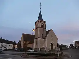 The church in Saint-Maurice-lès-Charencey | |
Location of Charencey | |
 Charencey 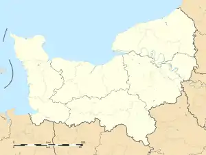 Charencey | |
| Coordinates: 48°39′02″N 0°45′33″E / 48.6506°N 0.7592°E | |
| Country | France |
| Region | Normandy |
| Department | Orne |
| Arrondissement | Mortagne-au-Perche |
| Canton | Tourouvre au Perche |
| Intercommunality | Hauts du Perche |
| Government | |
| • Mayor (2020–2026) | Jean-Claude Juszezak[1] |
| Area 1 | 45.56 km2 (17.59 sq mi) |
| Population | 762 |
| • Density | 17/km2 (43/sq mi) |
| Time zone | UTC+01:00 (CET) |
| • Summer (DST) | UTC+02:00 (CEST) |
| INSEE/Postal code | 61429 /61190 |
| 1 French Land Register data, which excludes lakes, ponds, glaciers > 1 km2 (0.386 sq mi or 247 acres) and river estuaries. | |
Charencey (French pronunciation: [ʃaʁɑ̃sɛ]) is a commune in the department of Orne, northwestern France. The municipality was established on 1 January 2018 by merger of the former communes of Saint-Maurice-lès-Charencey (the seat), Moussonvilliers and Normandel.[3]
See also
References
Wikimedia Commons has media related to Charencey (Orne).
- ↑ "Répertoire national des élus: les maires" (in French). data.gouv.fr, Plateforme ouverte des données publiques françaises. 13 September 2022.
- ↑ "Populations légales 2021". The National Institute of Statistics and Economic Studies. 28 December 2023.
- ↑ Arrêté préfectoral 22 September 2017 (in French)
This article is issued from Wikipedia. The text is licensed under Creative Commons - Attribution - Sharealike. Additional terms may apply for the media files.