Farmer City, Kansas | |
|---|---|
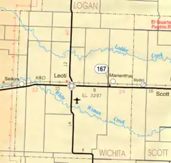 KDOT map of Wichita County (legend) | |
 Farmer City  Farmer City | |
| Coordinates: 38°17′8″N 101°11′35″W / 38.28556°N 101.19306°W | |
| Country | United States |
| State | Kansas |
| County | Wichita |
| Population | |
| • Total | 0 |
| Time zone | UTC-6 (CST) |
| • Summer (DST) | UTC-5 (CDT) |
| Area code | 620 |
Farmer City is a ghost town in Wichita County, Kansas, United States.
History
It was hoped that it would become the county seat — a compromise between the fighting towns of Leoti and Coronado. Soon after Leoti won the fight, Farmer City and most of Coronado vanished.
References
Further reading
External links
Municipalities and communities of Wichita County, Kansas, United States | ||
|---|---|---|
| City | 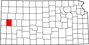 Map of Kansas highlighting Wichita County | |
| Unincorporated communities | ||
| Ghost towns | ||
| Footnotes | †This community is designated a Census-Designated Place (CDP) by the United States Census Bureau. | |
This article is issued from Wikipedia. The text is licensed under Creative Commons - Attribution - Sharealike. Additional terms may apply for the media files.