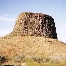
| Hat Rock State Park | |
|---|---|
 Hat Rock | |
  | |
| Type | Public, state |
| Location | Umatilla County, Oregon |
| Nearest city | Hermiston |
| Coordinates | 45°54′53″N 119°09′54″W / 45.9148548°N 119.1650109°W[1] |
| Operated by | Oregon Parks and Recreation Department |
Hat Rock State Park is a state park in the U.S. state of Oregon, administered by the Oregon Parks and Recreation Department. The park is located off the east side of U.S. Highway 730 in Hermiston,[2] on the south shore of Lake Wallula behind McNary Dam on the Columbia River.[3]
Flood basalt

Anchor, a landmark in the Park
Hat Rock is a geological formation that, along with another outcropping rock in the park called Boat Rock, are thought to be exposed remnants of a 12-million-year-old basalt flow. Floods from the Ice Age eventually left these bedrocks, as well as others along the Columbia River Gorge exposed at the surface of the Earth.[4] It is 70 feet (21 meters) high.
See also
References
- ↑ "Hat Rock State Park". Geographic Names Information System. United States Geological Survey, United States Department of the Interior. Retrieved June 21, 2011.
- ↑ Fanselow, Julie (2003). Traveling the Lewis and Clark Trail. Falcon. p. 252. ISBN 0-7627-2589-3.
- ↑ "McNary Dam and Lake Wallula". U.S. Army Corps of Engineers. Retrieved July 18, 2014.
- ↑ Bannan., Jan Gumprecht (2002). Oregon State Parks. Mountaineers Books. p. 212. ISBN 0-89886-794-0.
External links
- "Hat Rock State Park". Oregon Parks and Recreation Department. Retrieved June 21, 2011.
Wikimedia Commons has media related to Hat Rock State Park.
This article is issued from Wikipedia. The text is licensed under Creative Commons - Attribution - Sharealike. Additional terms may apply for the media files.