Holters Crossing, Pennsylvania | |
|---|---|
 Holters Crossing  Holters Crossing | |
| Coordinates: 40°58′20″N 77°43′24″W / 40.97222°N 77.72333°W | |
| Country | United States |
| State | Pennsylvania |
| County | Centre |
| Townships | Boggs Howard |
| Area | |
| • Total | 0.09 sq mi (0.24 km2) |
| • Land | 0.09 sq mi (0.24 km2) |
| • Water | 0.00 sq mi (0.00 km2) |
| Elevation | 678 ft (207 m) |
| Population | |
| • Total | 111 |
| • Density | 1,180.85/sq mi (456.77/km2) |
| Time zone | UTC-5 (Eastern (EST)) |
| • Summer (DST) | UTC-4 (EDT) |
| ZIP Code | 16841 (Howard) |
| Area code(s) | 814/582 |
| FIPS code | 42-35336 |
| GNIS feature ID | 2805511[3] |
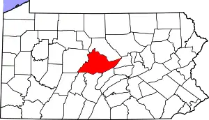
Holters Crossing is an unincorporated community and census-designated place (CDP) in Centre County, Pennsylvania, United States. It was first listed as a CDP prior to the 2020 census.[3]
The CDP is in northern Centre County, mostly in the southeastern part of Boggs Township and partly in the southwestern corner of Howard Township. It sits in the Bald Eagle Valley, on the south side of Bald Eagle Creek. County Route 1006 (old U.S. Route 220) is the main road through the community; it leads southwest 4 miles (6 km) to Milesburg and northeast 1.5 miles (2.4 km) to a dead end at Mount Eagle, at the head of Foster Joseph Sayers Reservoir, an impoundment on Bald Eagle Creek.
Bald Eagle Mountain rises to the southeast above Holters Crossing to a ridgecrest elevation of 1,560 feet (480 m).
Demographics
| Census | Pop. | Note | %± |
|---|---|---|---|
| 2020 | 111 | — | |
| U.S. Decennial Census[4] | |||
References
- ↑ "ArcGIS REST Services Directory". United States Census Bureau. Retrieved October 12, 2022.
- ↑ "Census Population API". United States Census Bureau. Retrieved October 12, 2022.
- 1 2 "Holters Crossing Census Designated Place". Geographic Names Information System. United States Geological Survey, United States Department of the Interior.
- ↑ "Census of Population and Housing". Census.gov. Retrieved June 4, 2016.
