Jones County | |
|---|---|
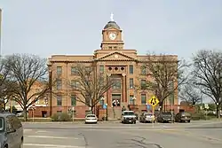
 Jones County Courthouse in Anson, Texas | |
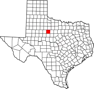
 Location within the U.S. state of Texas | |
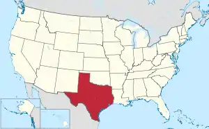
 Texas's location within the U.S. | |
| Coordinates: 32°44′N 99°53′W / 32.74°N 99.88°W | |
| Country | |
| State | |
| Founded | 1881 |
| Named for | Anson Jones |
| Seat | Anson |
| Largest city | Abilene |
| Area | |
| • Total | 937.1 sq mi (2,427 km2) |
| • Land | 928.6 sq mi (2,405 km2) |
| • Water | 8.6 sq mi (22 km2) 0.9% |
| Population (2020) | |
| • Total | 19,663 |
| • Density | 21/sq mi (8.1/km2) |
| Time zone | UTC−6 (Central) |
| • Summer (DST) | UTC−5 (CDT) |
| Congressional district | 19th |
| Website | www |
Jones County is a county located in the U.S. state of Texas. As of the 2020 census, its population was 19,663.[1] Its county seat is Anson.[2] The county was created in 1858 and organized in 1881.[3] Both the county and its county seat are named for Anson Jones, the fourth and final president of the Republic of Texas.[4]
Jones County is included in the Abilene, Texas, metropolitan statistical area.
Geography
According to the U.S. Census Bureau, the county has a total area of 937 square miles (2,430 km2), of which 929 square miles (2,410 km2) are land and 8.6 square miles (22 km2) (0.9%) are covered by water.[5]
Major highways
Adjacent counties
- Haskell County (north)
- Shackelford County (east)
- Callahan County (southeast)
- Taylor County (south)
- Fisher County (west)
- Stonewall County (northwest)
Demographics
| Census | Pop. | Note | %± |
|---|---|---|---|
| 1880 | 546 | — | |
| 1890 | 3,797 | 595.4% | |
| 1900 | 7,053 | 85.8% | |
| 1910 | 24,299 | 244.5% | |
| 1920 | 22,323 | −8.1% | |
| 1930 | 24,233 | 8.6% | |
| 1940 | 23,378 | −3.5% | |
| 1950 | 22,147 | −5.3% | |
| 1960 | 19,299 | −12.9% | |
| 1970 | 16,106 | −16.5% | |
| 1980 | 17,268 | 7.2% | |
| 1990 | 16,490 | −4.5% | |
| 2000 | 20,785 | 26.0% | |
| 2010 | 20,202 | −2.8% | |
| 2020 | 19,663 | −2.7% | |
| U.S. Decennial Census[6] 1850–2010[7] 2010[8] 2020[9] | |||
| Race / Ethnicity | Pop 2010[8] | Pop 2020[9] | % 2010 | % 2020 |
|---|---|---|---|---|
| White alone (NH) | 12,549 | 11,485 | 62.12% | 58.41% |
| Black or African American alone (NH) | 2,292 | 1,978 | 11.35% | 10.06% |
| Native American or Alaska Native alone (NH) | 62 | 66 | 0.31% | 0.34% |
| Asian alone (NH) | 76 | 111 | 0.38% | 0.56% |
| Pacific Islander alone (NH) | 1 | 4 | 0.00% | 0.02% |
| Some Other Race alone (NH) | 27 | 41 | 0.13% | 0.21% |
| Mixed Race/Multi-Racial (NH) | 186 | 474 | 0.92% | 2.41% |
| Hispanic or Latino (any race) | 5,009 | 5,504 | 24.79% | 27.99% |
| Total | 20,202 | 19,663 | 100.00% | 100.00% |
Note: the US Census treats Hispanic/Latino as an ethnic category. This table excludes Latinos from the racial categories and assigns them to a separate category. Hispanics/Latinos can be of any race.
As of the census[10] of 2000, 20,785 people, 6,140 households, and 4,525 families resided in the county. The population density was 22 people per square mile (8.5 people/km2). The 7,236 housing units averaged 8 units per square mile (3.1/km2). The racial makeup of the county was 78.80% White, 11.51% Black or African American, 0.49% Native American, 0.47% Asian, 7.47% from other races, and 1.27% from two or more races. About 20.9% of the population was Hispanic or Latino of any race.
Of the 6,140 households, 33.40% had children under the age of 18 living with them, 59.60% were married couples living together, 10.10% had a female householder with no husband present, and 26.30% were not families. About 24.1% of all households were made up of individuals, and 13.40% had someone living alone who was 65 years of age or older. The average household size was 2.58 and the average family size was 3.06.
In the county, theage distribution was 22.50% under 18, 11.10% from 18 to 24, 31.50% from 25 to 44, 21.00% from 45 to 64, and 14.00% who were 65 or older. The median age was 36 years. For every 100 females, there were 150.10 males. For every 100 females age 18 and over, there were 159.70 males.
The median income for a household in the county was $29,572, and for a family was $35,391. Males had a median income of $26,892 versus $17,829 for females. The per capita income for the county was $13,656. About 13.10% of families and 16.80% of the population were below the poverty line, including 22.70% of those under age 18 and 16.60% of those age 65 or over.
Government and infrastructure
The Texas Department of Criminal Justice (TDCJ) operates the Robertson Unit, located 10 miles from downtown.[11] The state Middleton Unit transfer unit is located partially in Abilene and also in Jones County.[12][13]
From 2007 to 2017 Republican Susan King represented Jones, Nolan, and Taylor Counties in the state house.[14]
Politics
“From their first presidential election in 1884 through 1992 the voters in Jones County have generally chosen Democratic candidates. They supported Republican candidates in 1928, 1952, 1972, 1984, and 1988.“ [15]
Since 2000, the majority of voters selected Republican presidential candidates, with the margin of victory for the party's candidates increasing in each election.
Jones County is part of the 71st district for elections to the Texas House of Representatives.
| Year | Republican | Democratic | Third party | |||
|---|---|---|---|---|---|---|
| No. | % | No. | % | No. | % | |
| 2020 | 5,660 | 83.96% | 999 | 14.82% | 82 | 1.22% |
| 2016 | 4,819 | 80.86% | 936 | 15.70% | 205 | 3.44% |
| 2012 | 4,262 | 76.56% | 1,226 | 22.02% | 79 | 1.42% |
| 2008 | 4,203 | 72.37% | 1,528 | 26.31% | 77 | 1.33% |
| 2004 | 4,254 | 71.72% | 1,658 | 27.95% | 19 | 0.32% |
| 2000 | 4,080 | 67.46% | 1,899 | 31.40% | 69 | 1.14% |
| 1996 | 2,351 | 43.46% | 2,422 | 44.77% | 637 | 11.77% |
| 1992 | 2,088 | 35.20% | 2,400 | 40.46% | 1,444 | 24.34% |
| 1988 | 3,000 | 50.71% | 2,898 | 48.99% | 18 | 0.30% |
| 1984 | 4,017 | 62.93% | 2,343 | 36.71% | 23 | 0.36% |
| 1980 | 2,765 | 47.07% | 3,043 | 51.80% | 66 | 1.12% |
| 1976 | 2,072 | 38.26% | 3,318 | 61.26% | 26 | 0.48% |
| 1972 | 3,202 | 75.11% | 1,050 | 24.63% | 11 | 0.26% |
| 1968 | 1,676 | 33.66% | 2,372 | 47.64% | 931 | 18.70% |
| 1964 | 1,295 | 26.32% | 3,622 | 73.62% | 3 | 0.06% |
| 1960 | 2,196 | 44.04% | 2,772 | 55.60% | 18 | 0.36% |
| 1956 | 2,073 | 44.32% | 2,594 | 55.46% | 10 | 0.21% |
| 1952 | 2,941 | 52.21% | 2,680 | 47.58% | 12 | 0.21% |
| 1948 | 432 | 10.34% | 3,599 | 86.16% | 146 | 3.50% |
| 1944 | 361 | 8.77% | 3,417 | 83.00% | 339 | 8.23% |
| 1940 | 401 | 9.79% | 3,688 | 90.08% | 5 | 0.12% |
| 1936 | 305 | 8.24% | 3,396 | 91.71% | 2 | 0.05% |
| 1932 | 224 | 7.03% | 2,934 | 92.03% | 30 | 0.94% |
| 1928 | 1,995 | 55.95% | 1,563 | 43.83% | 8 | 0.22% |
| 1924 | 566 | 15.39% | 3,010 | 81.86% | 101 | 2.75% |
| 1920 | 270 | 11.83% | 1,792 | 78.53% | 220 | 9.64% |
| 1916 | 114 | 5.34% | 1,798 | 84.18% | 224 | 10.49% |
| 1912 | 63 | 3.89% | 1,301 | 80.36% | 255 | 15.75% |
Communities
Cities
- Abilene (mostly in Taylor County)
- Anson (county seat)
- Hamlin (small part in Fisher County)
- Hawley
- Lueders (small part in Shackelford County)
- Stamford (small part in Haskell County)
Unincorporated communities
Notable person
- Charles Stenholm, former member of the United States House of Representatives
See also
References
- ↑ "Jones County, Texas". United States Census Bureau. Retrieved January 30, 2022.
- ↑ "Find a County". National Association of Counties. Archived from the original on May 31, 2011. Retrieved June 7, 2011.
- ↑ "Texas: Individual County Chronologies". Texas Atlas of Historical County Boundaries. The Newberry Library. 2008. Archived from the original on April 12, 2017. Retrieved May 24, 2015.
- ↑ Gannett, Henry (1905). The Origin of Certain Place Names in the United States. Govt. Print. Off. pp. 170.
- ↑ "2010 Census Gazetteer Files". United States Census Bureau. August 22, 2012. Retrieved May 2, 2015.
- ↑ "Decennial Census of Population and Housing by Decades". US Census Bureau.
- ↑ "Texas Almanac: Population History of Counties from 1850–2010" (PDF). Texas Almanac. Archived (PDF) from the original on October 9, 2022. Retrieved May 2, 2015.
- 1 2 "P2 HISPANIC OR LATINO, AND NOT HISPANIC OR LATINO BY RACE - 2010: DEC Redistricting Data (PL 94-171) - Jones County, Texas". United States Census Bureau.
- 1 2 "P2 HISPANIC OR LATINO, AND NOT HISPANIC OR LATINO BY RACE - 2020: DEC Redistricting Data (PL 94-171) - Jones County, Texas". United States Census Bureau.
- ↑ "U.S. Census website". United States Census Bureau. Retrieved May 14, 2011.
- ↑ "Robertson Unit Archived 2010-07-25 at the Wayback Machine." Texas Department of Criminal Justice. Retrieved on July 23, 2010.
- ↑ "Super Neighborhood Areas Archived 2011-06-09 at the Wayback Machine." (Direct map link Archived 2011-06-09 at the Wayback Machine) City of Abilene. Retrieved on July 23, 2010.
- ↑ "Middleton Unit Archived 2010-07-25 at the Wayback Machine." Texas Department of Criminal Justice. Retrieved on July 23, 2010.
- ↑ "Susan King". Texas Legislative Reference Library. Retrieved March 12, 2014.
- ↑ “TSHA“
- ↑ Leip, David. "Dave Leip's Atlas of U.S. Presidential Elections". uselectionatlas.org. Retrieved April 11, 2018.
External links
- Jones County government's website
- Jones County from the Handbook of Texas Online
- Jones County Profile from the Texas Association of Counties Archived November 13, 2013, at the Wayback Machine