Křeslice | |
|---|---|
Municipal District of Prague | |
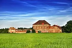
 Štít farmstead, formerly a fort | |
 Flag  Coat of arms | |
| Coordinates: 50°1′24″N 14°33′54″E / 50.02333°N 14.56500°E | |
| Country | Czech Republic |
| Region | Prague |
| District | Prague 11 |
| Time zone | UTC+1 (CET) |
| • Summer (DST) | UTC+2 (CEST) |
Křeslice is a municipal district (městská část) in Prague, Czech Republic.[1][2]
Demographics
| Year | Pop. | ±% |
|---|---|---|
| 1869 | 202 | — |
| 1880 | 239 | +18.3% |
| 1890 | 205 | −14.2% |
| 1900 | 213 | +3.9% |
| 1910 | 204 | −4.2% |
| 1921 | 217 | +6.4% |
| 1930 | 232 | +6.9% |
| 1950 | 199 | −14.2% |
| 1961 | 234 | +17.6% |
| 1970 | 184 | −21.4% |
| 1980 | 214 | +16.3% |
| 1991 | 235 | +9.8% |
| 2001 | 343 | +46.0% |
| 2011 | 979 | +185.4% |
| 2021 | 1,173 | +19.8% |
| Source: Censuses[3][4] | ||
References
- ↑ "Řeporyje". mistopisy. Retrieved 28 January 2019.
- ↑ "VODEST". Archived from the original on 29 January 2019. Retrieved 28 January 2019.
- ↑ "Historický lexikon obcí České republiky 1869–2011 – Praha" (in Czech). Czech Statistical Office. 2015-12-21. pp. 7–8.
- ↑ "Population Census 2021: Population by sex". Public Database. Czech Statistical Office. 2021-03-27.
This article is issued from Wikipedia. The text is licensed under Creative Commons - Attribution - Sharealike. Additional terms may apply for the media files.