Knifley | |
|---|---|
 Knifley Location within the state of Kentucky  Knifley Knifley (the United States) | |
| Coordinates: 37°14′34″N 85°11′22″W / 37.24278°N 85.18944°W | |
| Country | United States |
| State | Kentucky |
| County | Adair |
| Elevation | 718 ft (219 m) |
| Time zone | UTC-6 (Central (CST)) |
| • Summer (DST) | UTC-5 (CDT) |
| ZIP code | 42753[1] |
| Area code(s) | 270 and 364 |
| GNIS feature ID | 508402 |
Knifley is an unincorporated community near Columbia in Adair County, Kentucky, United States. Its elevation is 718 feet (219 m).[2] Knifley also has a volunteer fire department.
The Knifley Christian Church has an annual community fish fry every May for any & all free.
References
- ↑ "Knifley ZIP Code". zipdatamaps.com. 2022. Retrieved November 30, 2022.
- ↑ U.S. Geological Survey Geographic Names Information System: Knifley, Kentucky
http://usfiredept.com/knifley-area-volunteer-fire-department-12232.html
Municipalities and communities of Adair County, Kentucky, United States | ||
|---|---|---|
| City | 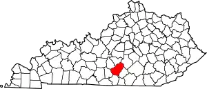 Location of Adair County, Kentucky | |
| Unincorporated communities |
| |
| Footnotes | ‡This populated place also has portions in an adjacent county or counties. | |
http://usfiredept.com/knifley-area-volunteer-fire-department-12232.html
This article is issued from Wikipedia. The text is licensed under Creative Commons - Attribution - Sharealike. Additional terms may apply for the media files.