Kopstal
Koplescht | |
|---|---|
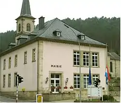 The town hall | |
.svg.png.webp) Coat of arms | |
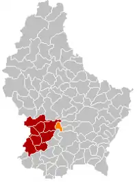 Map of Luxembourg with Kopstal highlighted in orange, and the canton in dark red | |
| Coordinates: 49°39′51″N 6°04′19″E / 49.664167°N 6.071944°E | |
| Country | |
| Canton | Capellen |
| Area | |
| • Total | 7.9 km2 (3.1 sq mi) |
| • Rank | 97th of 102 |
| Highest elevation | 392 m (1,286 ft) |
| • Rank | 59th of 102 |
| Lowest elevation | 245 m (804 ft) |
| • Rank | 55th of 102 |
| Population (2023) | |
| • Total | 4,286 |
| • Rank | 43rd of 102 |
| • Density | 540/km2 (1,400/sq mi) |
| • Rank | 17th of 102 |
| Time zone | UTC+1 (CET) |
| • Summer (DST) | UTC+2 (CEST) |
| LAU 2 | LU0000107 |
| Website | kopstal.lu |
Kopstal (Luxembourgish: Koplescht) is a commune and a small town in central Luxembourg. The towns of Kopstal and Bridel belong to this commune. Kopstal is a small town, with a population of 644 as of 2005, located in a valley between forested hills situated beneath Bridel.
It is in the countryside and at ten minutes distance driving from the capital. School children are able to attend the schools in the city and young people can enjoy Luxemburg City's night life. There are many paths through the forests next to Kopstal.
Kopstal was formed on 1 July 1853, when it was detached from the communes of Kehlen (in Capellen canton) and Steinsel (in Luxembourg canton). The law forming Kopstal was passed on the 22 February 1853.[1]
Population
Notable people
- Willy Kemp (1925–2021), a Luxembourgish professional road bicycle racer.
References
- ↑ (in French and German) "Mémorial A, 1853, No. 31" (PDF). Service central de législation. Retrieved 2006-08-15.
- ↑ "Population par canton et commune". statistiques.public.lu. Archived from the original on 12 September 2016. Retrieved 11 January 2022.
External links
 Media related to Kopstal at Wikimedia Commons
Places adjacent to Kopstal | |
|---|---|

This article is issued from Wikipedia. The text is licensed under Creative Commons - Attribution - Sharealike. Additional terms may apply for the media files.