Lecelles | |
|---|---|
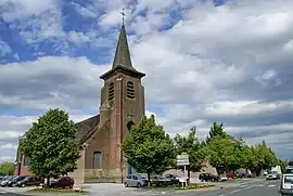 Lecelles, church: église Saint-Denis | |
_Nord-France.svg.png.webp) Coat of arms | |
Location of Lecelles | |
 Lecelles  Lecelles | |
| Coordinates: 50°28′17″N 3°23′43″E / 50.4714°N 3.3953°E | |
| Country | France |
| Region | Hauts-de-France |
| Department | Nord |
| Arrondissement | Valenciennes |
| Canton | Saint-Amand-les-Eaux |
| Intercommunality | CA Porte du Hainaut |
| Government | |
| • Mayor (2020–2026) | Jean-Claude Messager[1] |
| Area 1 | 16.24 km2 (6.27 sq mi) |
| Population | 3,004 |
| • Density | 180/km2 (480/sq mi) |
| Time zone | UTC+01:00 (CET) |
| • Summer (DST) | UTC+02:00 (CEST) |
| INSEE/Postal code | 59335 /59226 |
| Elevation | 15–26 m (49–85 ft) (avg. 17 m or 56 ft) |
| 1 French Land Register data, which excludes lakes, ponds, glaciers > 1 km2 (0.386 sq mi or 247 acres) and river estuaries. | |
Lecelles (French pronunciation: [ləsɛl]) is a commune in the Nord department in northern France.[3]
Population
| Year | Pop. | ±% p.a. |
|---|---|---|
| 1968 | 2,152 | — |
| 1975 | 2,356 | +1.30% |
| 1982 | 2,402 | +0.28% |
| 1990 | 2,563 | +0.81% |
| 1999 | 2,662 | +0.42% |
| 2007 | 2,733 | +0.33% |
| 2012 | 2,684 | −0.36% |
| 2017 | 2,810 | +0.92% |
| Source: INSEE[4] | ||
Gallery
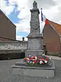 Lecelles, war memorial
 Lecelles, view to a street
 Lecelles, view to a street
Heraldry
Arms of Lecelles |
The arms of Lecelles are blazoned : Azure, semy de lys Or. = France Ancient (Ansacq, Brillon, Escaudain, Escautpont, Hélesmes, Hérin, Lecelles, Lieu-Saint-Amand, Lourches, Neuville-sur-Escaut, Rosult, Rumegies and Wignehies use the same arms.)
|
See also
References
- ↑ "Répertoire national des élus: les maires". data.gouv.fr, Plateforme ouverte des données publiques françaises (in French). 2 December 2020.
- ↑ "Populations légales 2021". The National Institute of Statistics and Economic Studies. 28 December 2023.
- ↑ INSEE commune file
- ↑ Population en historique depuis 1968, INSEE
Wikimedia Commons has media related to Lecelles.
This article is issued from Wikipedia. The text is licensed under Creative Commons - Attribution - Sharealike. Additional terms may apply for the media files.