Litoboř | |
|---|---|
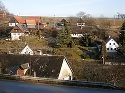
 General view | |
 Flag  Coat of arms | |
 Litoboř Location in the Czech Republic | |
| Coordinates: 50°27′0″N 16°0′55″E / 50.45000°N 16.01528°E | |
| Country | |
| Region | Hradec Králové |
| District | Náchod |
| First mentioned | 1369 |
| Area | |
| • Total | 3.52 km2 (1.36 sq mi) |
| Elevation | 394 m (1,293 ft) |
| Population (2023-01-01)[1] | |
| • Total | 111 |
| • Density | 32/km2 (82/sq mi) |
| Time zone | UTC+1 (CET) |
| • Summer (DST) | UTC+2 (CEST) |
| Postal code | 552 05 |
| Website | litobor |
Litoboř is a municipality and village in Náchod District in the Hradec Králové Region of the Czech Republic. It has about 100 inhabitants.
Geography
Litoboř is located about 11 km (7 mi) northwest of Náchod and 29 km (18 mi) northeast of Hradec Králové. It lies in the Giant Mountains Foothills. The highest point is at 465 m (1,526 ft) above sea level. The village is situated along the Hluboký Stream, which originates here.
Economy
The municipality has primarily been a leisure destination in recent decades. Less than 40% of dwellings are continuously occupied; the other houses are primarily utilised for individual recreation.[2]
References
- ↑ "Population of Municipalities – 1 January 2023". Czech Statistical Office. 2023-05-23.
- ↑ "Obec Litoboř" (in Czech). Obec Litoboř. Retrieved 2022-11-02.
Wikimedia Commons has media related to Litoboř.
This article is issued from Wikipedia. The text is licensed under Creative Commons - Attribution - Sharealike. Additional terms may apply for the media files.