Vernéřovice | |
|---|---|
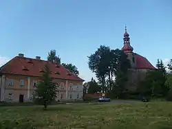
 Church of Saint Michael the Archangel and rectory | |
 Flag  Coat of arms | |
 Vernéřovice Location in the Czech Republic | |
| Coordinates: 50°28′6″N 16°13′39″E / 50.46833°N 16.22750°E | |
| Country | |
| Region | Hradec Králové |
| District | Náchod |
| First mentioned | 1351 |
| Area | |
| • Total | 9.41 km2 (3.63 sq mi) |
| Elevation | 453 m (1,486 ft) |
| Population (2023-01-01)[1] | |
| • Total | 311 |
| • Density | 33/km2 (86/sq mi) |
| Time zone | UTC+1 (CET) |
| • Summer (DST) | UTC+2 (CEST) |
| Postal code | 549 82 |
| Website | www |
Vernéřovice (German: Deutsch Wernersdorf) is a municipality and village in Náchod District in the Hradec Králové Region of the Czech Republic. It has about 300 inhabitants.
Geography
Vernéřovice is located about 22 km (14 mi) north of Náchod and 51 km (32 mi) northeast of Hradec Králové. It borders Poland in the north. It lies in the Broumov Highlands, in the Broumovsko Protected Landscape Area. The highest point is below the summit of the mountain Buková hora at 635 m (2,083 ft) above sea level. The village is situated along the Vernéřovický Brook, which originates here. The Stěnava River flows along the northeastern municipal border.
History
The first written mention of Vernéřovice is from 1351, when it was known as Wernhirsdorf.[2] The village was founded in the second half of the 13th century.[3]
Sights
The main landmark of Vernéřovice is the Church of Saint Michael the Archangel. It was built in the Baroque style in 1719–1723 according to the design by architect Christoph Dientzenhofer. For its value it has been protected as a national cultural monument since 2022.[4]
The pseudo-Gothic Church of Our Lady of Help was built in 1904. It is a pilgrimage site.[3]
References
- ↑ "Population of Municipalities – 1 January 2023". Czech Statistical Office. 2023-05-23.
- ↑ "Vernéřovice – stručná historie obce" (in Czech). Obec Vernéřovice. Retrieved 2022-10-31.
- 1 2 "Poutní místo Vernéřovice" (in Czech). Obec Vernéřovice. Retrieved 2023-07-21.
- ↑ "Kostel sv. Michaela archanděla" (in Czech). National Heritage Institute. Retrieved 2023-07-21.