Louka u Litvínova | |
|---|---|
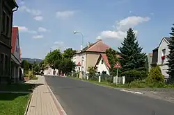
 Main street with the municipal office | |
 Flag  Coat of arms | |
 Louka u Litvínova Location in the Czech Republic | |
| Coordinates: 50°35′17″N 13°38′12″E / 50.58806°N 13.63667°E | |
| Country | |
| Region | Ústí nad Labem |
| District | Most |
| First mentioned | 1289 |
| Area | |
| • Total | 2.68 km2 (1.03 sq mi) |
| Elevation | 287 m (942 ft) |
| Population (2023-01-01)[1] | |
| • Total | 737 |
| • Density | 280/km2 (710/sq mi) |
| Time zone | UTC+1 (CET) |
| • Summer (DST) | UTC+2 (CEST) |
| Postal code | 435 33 |
| Website | www |
Louka u Litvínova (German: Wiese) is a municipality and village in Most District in the Ústí nad Labem Region of the Czech Republic. It has about 700 inhabitants.
Geography
Louka u Litvínova is located about 8 kilometres (5 mi) north of Most and 28 km (17 mi) west of Ústí nad Labem. It lies in the Most Basin. There are several ponds in the area.
History
The first written mention of Louka u Litvínova is from 1289, when it was owned by the Lords of Rýzmburk, a branch of the Hrabišic family. They sold the village to Margrave William I in 1398 and until the end of the Hussite Wars, the area belonged to Saxony. After that, the village was granted to various nobles as a fief.[2]
In the 17th century, Louka u Litvínova was owned by the Waldstein family. It was an agricultural village until the discovery of lignite and general industrialization of the region.[2]
Transport
Louka u Litvínova lies on two railway lines: Litvínov–Děčín and Rakovník–Osek.
Sights

The main landmark is the Chapel of Saint Anthony of Padua. It was built in 1834 from the money of local farmers.[2]
References
- ↑ "Population of Municipalities – 1 January 2023". Czech Statistical Office. 2023-05-23.
- 1 2 3 "Historie" (in Czech). Obec Louka u Litvínova. Retrieved 2023-06-01.