Most District
Okres Most | |
|---|---|
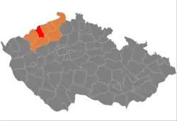 Location in the Ústí nad Labem Region within the Czech Republic | |
 | |
| Coordinates: 50°34′N 13°36′E / 50.567°N 13.600°E | |
| Country | |
| Region | Ústí nad Labem |
| Capital | Most |
| Area | |
| • Total | 467.10 km2 (180.35 sq mi) |
| Population (2023)[2] | |
| • Total | 108,116 |
| • Density | 230/km2 (600/sq mi) |
| Time zone | UTC+1 (CET) |
| • Summer (DST) | UTC+2 (CEST) |
| Municipalities | 26 |
| * Cities and towns | 6 |
| * Market towns | 0 |
Most District (Czech: okres Most) is a district in the Ústí nad Labem Region of the Czech Republic. Its capital is the city of Most.
Administrative division
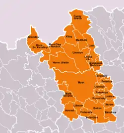
Most District is divided into two administrative districts of municipalities with extended competence: Most and Litvínov.
List of municipalities
Cities and towns are marked in bold:
Bečov - Bělušice - Braňany - Brandov - Český Jiřetín - Havraň - Hora Svaté Kateřiny - Horní Jiřetín - Klíny - Korozluky - Lišnice - Litvínov - Lom - Louka u Litvínova - Lužice - Malé Březno - Mariánské Radčice - Meziboří - Most - Nová Ves v Horách - Obrnice - Patokryje - Polerady - Skršín - Volevčice - Želenice
Geography

Most District borders Germany in the north. The terrain is very varied and goes from flat in the south to mountainous in the north. The territory extends into three geomorphological mesoregions: Most Basin (southwest and centre), Ore Mountains (north) and Central Bohemian Uplands (southeast). The highest point of the district is the mountain Loučná in Lom with an elevation of 956 m (3,136 ft), the lowest point is the river bed of the Bílina in Želenice at 204 m (669 ft).
From the total district area of 467.1 km2 (180.3 sq mi), agricultural land occupies 133.5 km2 (51.5 sq mi), forests occupy 161.6 km2 (62.4 sq mi), and water area occupies 11.1 km2 (4.3 sq mi). Forests cover 34.6% of the district's area.[1]
The most important river is the Bílina, which drains the entire territory. Its most important tributary is the Srpina. The largest body of water is Most Lake, an artificial lake with an area of 311 ha (770 acres). Notable is also Fláje Reservoir with an area of 153 ha (380 acres).
České Středohoří is a protected landscape area that extends into the district, with a small part in the southeast of the district.
Demographics
|
|
| ||||||||||||||||||||||||||||||||||||||||||||||||||||||
| Source: Censuses[3][4] | ||||||||||||||||||||||||||||||||||||||||||||||||||||||||
Most populated municipalities
| Name | Population[2] | Area (km2) |
|---|---|---|
| Most | 63,856 | 87 |
| Litvínov | 22,695 | 41 |
| Meziboří | 4,627 | 14 |
| Lom | 3,701 | 17 |
| Horní Jiřetín | 2,206 | 40 |
| Obrnice | 2,057 | 7 |
| Bečov | 1,389 | 28 |
| Braňany | 1,197 | 6 |
Economy
The largest employers with headquarters in Most District and at least 500 employees are:[5]
| Economic entity | Location | Number of employees | Main activity |
|---|---|---|---|
| Orlen Unipetrol | Litvínov | 2,000–2,499 | Crude oil processing and manufacture of plastics |
| Yankee Candle | Havraň | 500–999 | Manufacture of candles |
| BIS Czech | Horní Jiřetín | 500–999 | Maintenance of machinery |
| City of Most | Most | 500–999 | Public administration |
| Sev.en Inntech | Most | 500–999 | Support activities for mining |
| Severní energetická | Most | 500–999 | Coal mining |
| Vršanská uhelná | Most | 500–999 | Coal mining |
Transport
There are no motorways in the district territory. The most important road that passess through the district is the I/13 from Karlovy Vary to Liberec.
Sights

The most important monuments in the district, protected as national cultural monuments, are:[6]
- Church of the Assumption of the Virgin Mary in Most
- Jezeří Castle in Horní Jiřetín
The best-preserved settlement, which is the only one protected as a monument zone, is Litvínov-Osada.[7]
The most visited tourist destination is the Jezeří Castle.[8]
Notable people
References
- 1 2 "Land use (as at 31 December)". Public database. Czech Statistical Office. Retrieved 2023-05-17.
- 1 2 "Population of Municipalities – 1 January 2023". Czech Statistical Office. 2023-05-23.
- ↑ "Historický lexikon obcí České republiky 1869–2011 – Okres Most" (in Czech). Czech Statistical Office. 2015-12-21. pp. 1–2.
- ↑ "Population Census 2021: Population by sex". Public Database. Czech Statistical Office. 2021-03-27.
- ↑ "Registr ekonomických subjektů". Business Register (in Czech). Czech Statistical Office. Retrieved 2023-01-20.
- ↑ "Výsledky vyhledávání: Národní kulturní památky, okres Most". Ústřední seznam kulturních památek (in Czech). National Heritage Institute. Retrieved 2023-01-20.
- ↑ "Výsledky vyhledávání: Památkové rezervace, Památkové zóny, okres Most". Ústřední seznam kulturních památek (in Czech). National Heritage Institute. Retrieved 2023-01-20.
- ↑ "Návštěvnost památek 2021" (in Czech). Národní informační a poradenské středisko pro kulturu. Retrieved 2023-03-20.
External links
- Most District – profile on the Czech Statistical Office website