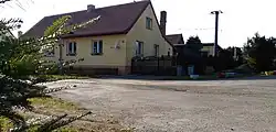
Luboměř pod Strážnou | |
|---|---|
 Centre of Luboměř pod Strážnou | |
 Flag  Coat of arms | |
 Luboměř pod Strážnou Location in the Czech Republic | |
| Coordinates: 49°41′24″N 17°39′39″E / 49.69000°N 17.66083°E | |
| Country | |
| Region | Olomouc |
| District | Přerov |
| First mentioned | 1394 |
| Area | |
| • Total | 9.58 km2 (3.70 sq mi) |
| Elevation | 600 m (2,000 ft) |
| Population (2023-01-01)[1] | |
| • Total | 126 |
| • Density | 13/km2 (34/sq mi) |
| Time zone | UTC+1 (CET) |
| • Summer (DST) | UTC+2 (CEST) |
| Postal code | 753 62 |
| Website | www |
Luboměř pod Strážnou is a municipality and village in Přerov District in the Olomouc Region of the Czech Republic. It has about 100 inhabitants.
History
The first written mention of Luboměř pod Strážnou is from 1394.[2]
After World War II, the population was displaced and the municipality was incorporated into the newly established Libavá Military Training Area. The territory of the village was used to accommodate employees, which saved it from complete extinction. Luboměř pod Strážnou became again a separate municipality on 1 January 2016 by reduction of Libavá Military Training Area.[2]
References
- ↑ "Population of Municipalities – 1 January 2023". Czech Statistical Office. 2023-05-23.
- 1 2 "Historie obce" (in Czech). Obec Luboměř pod Strážnou. Retrieved 2022-02-02.
Wikimedia Commons has media related to Luboměř pod Strážnou.
This article is issued from Wikipedia. The text is licensed under Creative Commons - Attribution - Sharealike. Additional terms may apply for the media files.