Mastník | |
|---|---|
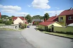 Centre of Mastník | |
 Coat of arms | |
 Mastník Location in the Czech Republic | |
| Coordinates: 49°10′49″N 15°49′40″E / 49.18028°N 15.82778°E | |
| Country | |
| Region | Vysočina |
| District | Třebíč |
| First mentioned | 1406 |
| Area | |
| • Total | 5.30 km2 (2.05 sq mi) |
| Elevation | 508 m (1,667 ft) |
| Population (2023-01-01)[1] | |
| • Total | 213 |
| • Density | 40/km2 (100/sq mi) |
| Time zone | UTC+1 (CET) |
| • Summer (DST) | UTC+2 (CEST) |
| Postal code | 675 22 |
| Website | www |
Mastník is a municipality and village in Třebíč District in the Vysočina Region of the Czech Republic. It has about 200 inhabitants.
Geography
Mastník is located in the Jevišovice Uplands. The highest points of the municipality are hills Kání hora and Pekelný kopec, both with an altitude of 570 metres (1,870 ft).
Notable people
- Jan Zahradníček (1905–1960), poet
References
Wikimedia Commons has media related to Mastník (Třebíč District).
This article is issued from Wikipedia. The text is licensed under Creative Commons - Attribution - Sharealike. Additional terms may apply for the media files.