Olešná | |
|---|---|
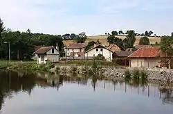 Pond in the centre of Olešná | |
 Flag 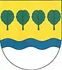 Coat of arms | |
 Olešná Location in the Czech Republic | |
| Coordinates: 49°26′45″N 15°15′49″E / 49.44583°N 15.26361°E | |
| Country | |
| Region | Vysočina |
| District | Pelhřimov |
| First mentioned | 1379 |
| Area | |
| • Total | 12.74 km2 (4.92 sq mi) |
| Elevation | 517 m (1,696 ft) |
| Population (2023-01-01)[1] | |
| • Total | 573 |
| • Density | 45/km2 (120/sq mi) |
| Time zone | UTC+1 (CET) |
| • Summer (DST) | UTC+2 (CEST) |
| Postal code | 393 01 |
| Website | www |
Olešná is a municipality and village in Pelhřimov District in the Vysočina Region of the Czech Republic. It has about 600 inhabitants.
Olešná lies approximately 4 kilometres (2 mi) east of Pelhřimov, 25 km (16 mi) west of Jihlava, and 94 km (58 mi) south-east of Prague.
Administrative parts
Villages of Chválov, Plevnice and Řemenov are administrative parts of Olešná.
History
From 1 January 1980 to 23 November 1990, Olešná was administratively part of the town of Pelhřimov.[2]
References
- ↑ "Population of Municipalities – 1 January 2023". Czech Statistical Office. 2023-05-23.
- ↑ "Historický lexikon obcí České republiky 1869–2011" (in Czech). Czech Statistical Office. 2015-12-21. pp. 195, 394, 428, 495.
Wikimedia Commons has media related to Olešná (Pelhřimov District).
This article is issued from Wikipedia. The text is licensed under Creative Commons - Attribution - Sharealike. Additional terms may apply for the media files.