Otobe
乙部町 | |
|---|---|
Town | |
 Otobe Town hall | |
 Flag  Seal | |
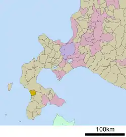
 Location of Otobe in Hokkaido (Hiyama Subprefecture) | |
 Otobe Location in Japan | |
| Coordinates: 41°58′N 140°8′E / 41.967°N 140.133°E | |
| Country | Japan |
| Region | Hokkaido |
| Prefecture | Hokkaido (Hiyama Subprefecture) |
| District | Nishi |
| Government | |
| • Mayor | Tsutomu Terashima |
| Area | |
| • Total | 162.55 km2 (62.76 sq mi) |
| Population (September 30, 2016) | |
| • Total | 3,925 |
| • Density | 24/km2 (63/sq mi) |
| Time zone | UTC+09:00 (JST) |
| City hall address | 388 Midoricho, Otobe, Nishi District, Hokkaido 043-0103 |
| Website | www |
| Symbols | |
| Flower | Lilium |
| Tree | Cryptomeria |
Otobe (乙部町, Otobe-chō) is a town located in Hiyama Subprefecture, Hokkaido, Japan.
As of September 2016, the town has an estimated population of 3,925, and a density of 24 persons per km2. The total area is 162.55 km2.
Geography
Otobe is located on the western of the Oshima Peninsula and faces the Sea of Japan.
The name came from Ainu word that means "The river with a marsh in its estuary". This river is Hime River, which flows through the town.[1]
Neighboring towns
- Hiyama Subprefecture
- Oshima Subprefecture
History
- 1902: Otobe became a Second Class Village.[2]
- 1965: Otobe Village became Otobe Town.
Education
- Junior high school
- Otobe Junior High School
- Elementary schools
- Otobe Elementary School
- Sakaehama Elementary School
- Meiwa Elementary School
References
External links
 Media related to Otobe, Hokkaidō at Wikimedia Commons
- Official Website (in Japanese)
This article is issued from Wikipedia. The text is licensed under Creative Commons - Attribution - Sharealike. Additional terms may apply for the media files.