Penukal Abab Lematang Ilir Regency
Kabupaten Penukal Abab Lematang Ilir PALI Regency | |
|---|---|
|
Coat of arms | |
| Nickname: PALI | |
| Motto: Serepat Serasan | |
 Location within South Sumatra | |
| Coordinates: 3°12′48″S 104°05′14″E / 3.2134°S 104.0872°E | |
| Country | Indonesia |
| Province | South Sumatra |
| Established | 11 January 2013 |
| Founded by | Government of Indonesia |
| Regency seat | Talang Ubi |
| Government | |
| • Type | Regency Government |
| • Regent | Heri Amalindo |
| • Vice Regent | Ferdian Andreas Lacony |
| Area | |
| • Total | 1,840.00 km2 (710.43 sq mi) |
| Population (mid 2022 estimate)[1] | |
| • Total | 200,368 |
| • Density | 110/km2 (280/sq mi) |
| • Ethnicity | Malay Javanese |
| Time zone | UTC+7 (Indonesia Western Standard Time) |
| Postcode | 312xx |
| Area code | (+62) 713 |
| Website | palikab.go.id |

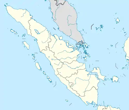
Penukal Abab Lematang Ilir Regency (often abbreviated to PALI) is a regency of South Sumatra Province, Indonesia. It takes its name from the three main rivers which flow through that area - the Penukal River, Abab River and Lematang River - while the name Ilir means "downstream" (denoting the downstream part of the Lematang River). The town of Talang Ubi is the administrative centre of this regency. The regency borders Musi Banyuasin Regency to the north, Banyuasin Regency, and Muara Enim Regency to the east and the south, and by Musi Rawas Regency, and Muara Enim Regency to the west.[2]
The regency was established on 14 December 2012, comprising five districts which were formerly part of Muara Enim Regency.[3] These five districts had a combined area of 1,840.00 km2 and a population of 165,474 at the 2010 Census[4] and 194,900 at the 2020 Census;[5] the official estimate as at mid 2022 was 200,368.[1]
Administrative districts
Penukal Abab Lematang Ilir Regency is composed of the following five districts (kecamatan), listed below with their areas and populations at the 2010 Census[4] and 2020 Census,[5] together with the official estimates as at mid 2022.[1] The table also includes the locations of the district administrative centres, the number of administrative villages in each district (totaling 65 rural desa and 6 urban kelurahan), and its postal code.
| Kode Wilayah | Name of District (kecamatan) | Area in km2 | Pop'n Census 2010 | Pop'n Census 2020 | Pop'n Estimate mid 2022 | Admin centre | No. of villages | Post code |
|---|---|---|---|---|---|---|---|---|
| 16.12.01 | Talang Ubi (a) | 648.40 | 67,258 | 83,669 | 86,910 | Handayani Mulia | 20 (b) | 31214 (c) |
| 16.12.05 | Tanah Abang | 156.60 | 27,237 | 30,576 | 31,140 | Tanah Abang Selatan | 17 | 31314 |
| 16.12.04 | Abab | 416.00 | 23,207 | 27,058 | 27,760 | Prabumenang | 8 | 31315 |
| 16.12.03 | Penukal | 272.00 | 26,978 | 30,178 | 30,710 | Babat | 13 | 31316 |
| 16.12.02 | Penukal Utara (North Penukal) | 347.00 | 20,794 | 23,419 | 23,860 | Betung | 13 | 31317 |
| Totals | 1,840.00 | 154,474 | 194,900 | 200,368 | Talang Ubi | 71 |
Not: (a) the four kelurahan forming Talang Ubi town (Talang Ubi Barat, Talang Ubi Selatan, Talang Ubi Timur and Talang Ubi Utara) together cover 128.36 km2 with a population of 34,330 at the 2020 Census.[5]
(b) of which 6 are urban kelurahan and 14 are rural desa.
(c) 17 villages within the district share the postcode of 31214 (including Talang Ubi Utara); the others are Talang Ubi Barat (with postcode of 31211), Talang Ubi Selatan (with postcode of 31212) and Talang Ubi Timur (with postcode of 31213).
See also
References
- 1 2 3 Badan Pusat Statistik, Jakarta, 2023, Kabupaten Penukal Abab Lematang Ilir Dalam Angka 2023 (Katalog-BPS 1102001.1612)
- ↑ "Selamat Datang di Kabupaten Pali". palikab.go.id. Archived from the original on 2015-07-15.
- ↑ DPR Sahkan 7 Kabupaten Baru. www.kompas.com. Sabtu, 15 December 2012. Accessed 30 December 2012
- 1 2 Biro Pusat Statistik, Jakarta, 2011.
- 1 2 3 Badan Pusat Statistik, Jakarta, 2021.
Regencies and cities of South Sumatra | ||
|---|---|---|
Capital: Palembang | ||
| Regencies | ||
| Cities | ||