Qalqilya Governorate | |
|---|---|
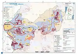
 2018 United Nations map of the area, showing the Israeli occupation arrangements in the governorate | |
 | |
| Country | |
| Area | |
| • Total | 164 km2 (63 sq mi) |
| Population (2017)[1] | |
| • Total | 91,046 |
| This figure excludes the Israeli West Bank Settlements | |
| Governorates of the West Bank (State of Palestine) |
|---|
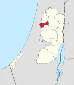
The Qalqilya Governorate or Qalqiliya Governorate (Arabic: محافظة قلقيلية, romanized: Muḥāfaẓat Qalqīlya) is an administrative area of Palestine in the northwestern West Bank.[2] Its capital or muhfaza (seat) is the city of Qalqilya that borders the Green Line.[3]
Localities
Municipalities
Towns and villages
References
- ↑ "Main Indicators by Type of Locality - Population, Housing and Establishments Census 2017" (PDF). Palestinian Central Bureau of Statistics (PCBS). Retrieved 2021-01-19.
- ↑ "مركز المعلومات الوطني الفلسطيني". 2018-07-06. Archived from the original on 6 July 2018. Retrieved 2022-06-21.
- ↑ Aburas, Hala; Shahrour, Isam (January 2021). "Impact of the Mobility Restrictions in the Palestinian Territory on the Population and the Environment". Sustainability. 13 (23): 13457. doi:10.3390/su132313457. ISSN 2071-1050.
This article is issued from Wikipedia. The text is licensed under Creative Commons - Attribution - Sharealike. Additional terms may apply for the media files.

