Slovincian Coast
Wybrzeże Słowińskie Słowińsczé Ùbrzeżé (in Kashubian) | |
|---|---|
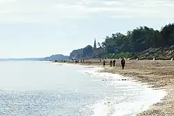 Beach in Sarbinowo | |
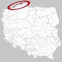 Location of the Slovincian Coast in Poland | |
| Country | |
| Area | |
| • Total | 1,132 km2 (437 sq mi) |
| Time zone | UTC+1 (CET) |
| • Summer (DST) | UTC+2 (CEST) |
The Slovincian Coast (Polish: Wybrzeże Słowińskie; Kashubian: Słowińsczé Ùbrzeżé) (313.41) is a mesoregion, the northernmost part of the Koszalin Coast, with an area of 1132 km2.[1] The highest hill is Rowokół, at 114,8 metres above sea level. The coast stretches from the west at Kołobrzeg, up to the east at Karwia. The landscape mainly compromises of dunes, marshland and lakes (such as Łebsko Lake).[2] The region is sparsely populated. The towns of Łeba, Ustka, Darłowo and Mielno are located on the coast. In the region of the Slovincian Coast is the Słowiński National Park,[3] and the spas of Ustka and Dąbki.
References
- ↑ "Onet, Wiem". Portal Wiedzy. Retrieved 2 May 2015.
- ↑ "Wybrzeże Słowińskie". Witaj W Podróży. Retrieved 2 May 2015.
- ↑ "Wirtualna Polska". Turystyka Wirtualna Polska. Retrieved 2 May 2015.

This article is issued from Wikipedia. The text is licensed under Creative Commons - Attribution - Sharealike. Additional terms may apply for the media files.