Trzebiatów Coast
Wybrzeże Trzebiatowskie | |
|---|---|
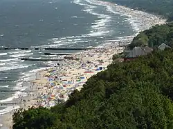 Beach in Niechorze | |
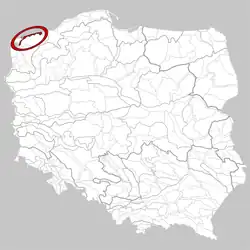 The location of the Trzebiatów Coast | |
| Country | Poland |
| Voivodeship | West Pomeranian Voivodeship |
| Area | |
| • Total | 290 km2 (110 sq mi) |
| Time zone | UTC+1 (CET) |
| • Summer (DST) | UTC+2 (CEST) |
The Trzebiatów Coast is a Polish mesoregion located on the Bay of Pomerania. It is 60 kilometres (37 mi) long and stretches from the Dziwna to Kołobrzeg. It has an area of 290 square kilometres (110 sq mi) and its shore is roughly 60 kilometres (37 mi) long.
The coast is known for its abundance of beaches, which are popular seaside resorts and summer tourist destinations in Poland. Such include (east to west): Dźwirzyno, Mrzeżyno, Pogorzelica, Niechorze, Rewal, Trzęsacz, Pustkowo, Pobierowo, Dziwnówek.

This article is issued from Wikipedia. The text is licensed under Creative Commons - Attribution - Sharealike. Additional terms may apply for the media files.