22°51′54″N 120°23′22″E / 22.865104°N 120.389503°E
Tianliao
田寮區 | |
|---|---|
| Tianliao District [1] | |
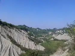
 Badlands formation in Tianliao | |
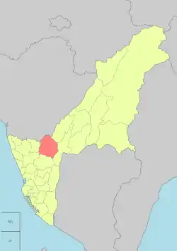
 Tianliao District in Kaohsiung City | |
| Country | Taiwan |
| Region | Southern Taiwan |
| Population (October 2023) | |
| • Total | 6,555 |
| Website | tianliao |
Tianliao District (Chinese: 田寮區; pinyin: Tiánliáo Qū; Wade–Giles: T'ien2-liao2 Ch'ü1) is a suburban district of Kaohsiung City, Taiwan.
History
After the handover of Taiwan from Japan to the Republic of China in 1945, Tianliao was organized as a rural township of Kaohsiung County. On 25 December 2010, Kaohsiung County merged with Kaohsiung City and Tianliao was upgraded to a district of the city.
Administrative divisions
The district consists of Lupu, Nanan, Datong, Tianliao, Qixing, Chongde, Xide, Sanhe, Guting and Xinxing Village.[2]
Tourist attractions
- Agongdian Reservoir
- Chaoyuan Temple (朝元寺)
- Danantian Fude Temple (大南天福德祠)
- Lyu Family Ancient House
- Mount Matou
- Narrow Sky
- Rihyue Temple (日月禪寺)
- Shihmuru
- Shihzueizai Pavilion
- Tianliao Moon World
Notable natives
- Su Jain-rong, Minister of Finance
See also
References
- ↑ "Glossary of Names for Admin Divisions" (PDF). placesearch.moi.gov.tw. Ministry of Interior of the ROC. Archived from the original (PDF) on 19 August 2015. Retrieved 12 June 2015.
- ↑ https://www.cec.gov.tw/pc/en/TV/nm64000002200000000.html
External links
Wikimedia Commons has media related to Tianliao District, Kaohsiung.
This article is issued from Wikipedia. The text is licensed under Creative Commons - Attribution - Sharealike. Additional terms may apply for the media files.