Typallia was a town of ancient Lycia.[1]
Its site is located on a rocky hill called Asarlık Tepe near the modern village of Çitdibi.
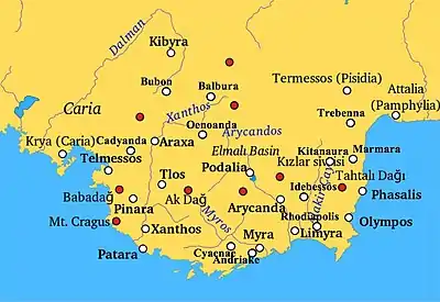
It is on the ancient road between Trebenna and Kitanaura as is clearly recorded on the Miliarium Lyciae. The inscriptions on the sarcophagi record the name of the settlement which was localised for the first time by İplikçioğlu.[2] He also determined that the settlement formed a sympoliteia together with Termessos.
The acropolis is on top of the hill and on its south slopes is the settlement. The entrance to the acropolis is cut into the bedrock.
On the southeast slope of the acropolis are the reasonably well-preserved baths, still standing to the level of the upper walls.[3] It comprises three rooms side by side and is a good example of Roman period provincial baths. The walls were plastered inside and out and the white marble plaques and marble plate fragments establish beyond doubt the function of this building.[4]
References
- ↑ Richard Talbert, ed. (2000). Barrington Atlas of the Greek and Roman World. Princeton University Press. p. 65, and directory notes accompanying.
- ↑ B. İplikçioğlu – V. Çelgin – G. Çelgin, Epigraphische Forschungen in Termessos und seinem Territorium IV (in print); B. İplikçioğlu, “Doğu Likya’da Epigrafik Araştırmalar”, Symposium on Lycia 2006, I, 328.
- ↑ Çevik, Nevzat (2008). "Northeast Lycia. The New Evidence - The Results from the past ten years from the Bey Mountains Surface Surveys". Adalya. 11: 199.
- ↑ Çevik, Nevzat; Varkıvanç, Burhan (2004). "An Evaluation of the Roman Rural Baths of Lycia in the Light of Two New Examples from Trebenna and Typallia". Adalya. 7: 223–250.
36°48′27″N 30°26′41″E / 36.807500°N 30.444722°E