Vrchteplá | |
|---|---|
Municipality | |
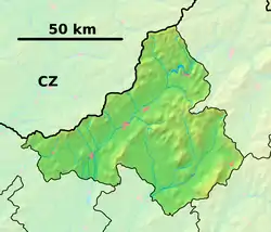 Vrchteplá Location of Vrchteplá in the Trenčín Region  Vrchteplá Vrchteplá (Slovakia) | |
| Coordinates: 49°08′N 18°34′E / 49.133°N 18.567°E | |
| Country | Slovakia |
| Region | Trenčín |
| District | Považská Bystrica |
| First mentioned | 1430 |
| Area | |
| • Total | 4.897 km2 (1.891 sq mi) |
| Elevation | 520 m (1,710 ft) |
| Population | |
| • Total | 256 |
| • Density | 52/km2 (140/sq mi) |
| Postal code | 017 05 (Považská Bystrica 5) |
| Area code | 421-42 |
| Car plate | PB |
| Website | www.vrchtepla.sk |
Vrchteplá (Hungarian: Felsőhéve) is a village and municipality in Považská Bystrica District in the Trenčín Region of north-western Slovakia.
History
In historical records the village was first mentioned in 1430.
Geography
The municipality lies at an altitude of 520 metres and covers an area of 4.897 km2. It has a population of about 256 people.
External links
- Official website

- https://web.archive.org/web/20080208225314/http://www.statistics.sk/mosmis/eng/run.html
Municipalities of Považská Bystrica District | ||
|---|---|---|
This article is issued from Wikipedia. The text is licensed under Creative Commons - Attribution - Sharealike. Additional terms may apply for the media files.