Vysoká | |
|---|---|
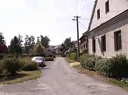
 Centre of Vysoká | |
_vlajka.jpg.webp) Flag _znak.jpg.webp) Coat of arms | |
 Vysoká Location in the Czech Republic | |
| Coordinates: 50°15′41″N 17°35′25″E / 50.26139°N 17.59028°E | |
| Country | |
| Region | Moravian-Silesian |
| District | Bruntál |
| First mentioned | 1267 |
| Area | |
| • Total | 17.12 km2 (6.61 sq mi) |
| Elevation | 280 m (920 ft) |
| Population (2023-01-01)[1] | |
| • Total | 314 |
| • Density | 18/km2 (48/sq mi) |
| Time zone | UTC+1 (CET) |
| • Summer (DST) | UTC+2 (CEST) |
| Postal code | 793 99 |
| Website | www |
Vysoká (German: Waißak) is a municipality and village in Bruntál District in the Moravian-Silesian Region of the Czech Republic. It has about 300 inhabitants.
Administrative parts

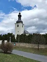
Church of Saint Urban
Villages of Bartultovice and Pitárné are administrative parts of Vysoká.
Geography
Vysoká is located about 31 kilometres (19 mi) north of Bruntál and 66 km (41 mi) northwest of Ostrava. It situated in the Osoblažsko microregion on the border with Poland. It lies in the Zlatohorská Highlands. The Osoblaha flows across the territory. The village of Pitárne is located at the confluence of the Osoblaha with the Mušlov Creek.
History
The first written mention of Vysoká is from 1267.[2]
Demographics
|
|
| ||||||||||||||||||||||||||||||||||||||||||||||||||||||
| Source: Censuses[3][4] | ||||||||||||||||||||||||||||||||||||||||||||||||||||||||
Sights
The landmarks of Vysoká are the Church of Saint Urban from 1767 and Church of the Virgin Mary in Pitárné from 1766.[2]
References
- ↑ "Population of Municipalities – 1 January 2023". Czech Statistical Office. 2023-05-23.
- 1 2 "Obec" (in Czech). Obec Vysoká. Retrieved 2022-05-09.
- ↑ "Historický lexikon obcí České republiky 1869–2011 – Okres Bruntál" (in Czech). Czech Statistical Office. 2015-12-21. pp. 13–14.
- ↑ "Population Census 2021: Population by sex". Public Database. Czech Statistical Office. 2021-03-27.
External links
Wikimedia Commons has media related to Vysoká (Bruntál District).
This article is issued from Wikipedia. The text is licensed under Creative Commons - Attribution - Sharealike. Additional terms may apply for the media files.