| Whetstone Mountain | |
|---|---|
 | |
| Highest point | |
| Elevation | 12,527 ft (3,818 m)[1][2] |
| Prominence | 2,456 ft (749 m)[3] |
| Isolation | 9.39 mi (15.11 km)[3] |
| Listing | Colorado prominent summits |
| Coordinates | 38°49′20″N 106°58′48″W / 38.8223016°N 106.9798991°W[1] |
| Geography | |
 Whetstone Mountain | |
| Location | Gunnison County, Colorado, United States[4] |
| Parent range | West Elk Mountains[3] |
| Topo map | USGS 7.5' topographic map Crested Butte, Colorado[1] |
| Climbing | |
| Easiest route | hike |
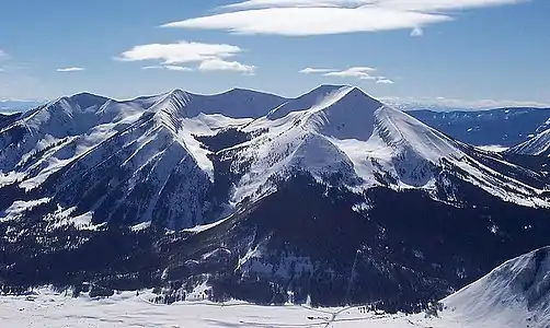
Whetstone Mountain, elevation 12,527 ft (3,818 m), is a summit in the Gunnison National Forest of western Colorado. The mountain is located 3 mi (4.8 km) south of Crested Butte in Gunnison County. Whetstone Mountain is one of several prominent laccoliths found in the West Elk Mountains.
Geology
Whetstone Mountain is a laccolith, formed when magma intruded into sedimentary strata of Mancos Shale and the Mesaverde Formation approximately 30 million years ago. Subsequent erosion has removed the softer, overlying sedimentary rock thereby exposing the more resistant igneous rock that characterizes the mountain today. The mountain is composed of quartz monzonite porphyry and granodiorite porphyry. Whetstone Mountain was glaciated, and the most prominent glacial cirques are located on the north side of the mountain.[5][6]
The mountain's name stems from rock collected in the area by the Hayden Survey during the early 1870s. Whetstones (also called hornfels) are contact metamorphic rocks useful for sharpening tools.[4]
Historical names
- Wheatstone Mountain
- Whetstone Mountain – 1927 [4]
See also
References
- 1 2 3 "WHETSTONE MTN CAIRN". NGS Data Sheet. National Geodetic Survey, National Oceanic and Atmospheric Administration, United States Department of Commerce. Retrieved October 23, 2014.
- ↑ The elevation of Whetstone Mountain includes an adjustment of +1.922 m (+6.31 ft) from NGVD 29 to NAVD 88.
- 1 2 3 "Whetstone Mountain, Colorado". Peakbagger.com. Retrieved October 23, 2014.
- 1 2 3 "Whetstone Mountain". Geographic Names Information System. United States Geological Survey, United States Department of the Interior. Retrieved November 14, 2014.
- ↑ Prather, Thomas (1999). Geology of the Gunnison Country (2nd ed.). Gunnison, Colorado: B&B Printers. LCCN 82-177244.
- ↑ Gaskill, David. L.; Colman, Steven M.; Delong, J. E.; Robinson, Charles H. (1986). Geologic map of the Crested Butte quadrangle, Gunnison County, Colorado. Washington, DC: U.S. Geological Survey. Retrieved 11 November 2020.