Bernardvillé | |
|---|---|
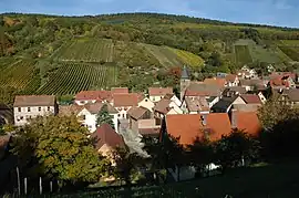 A general view of Bernardvillé | |
 Coat of arms | |
Location of Bernardvillé | |
 Bernardvillé  Bernardvillé | |
| Coordinates: 48°22′14″N 7°24′08″E / 48.3706°N 7.4022°E | |
| Country | France |
| Region | Grand Est |
| Department | Bas-Rhin |
| Arrondissement | Sélestat-Erstein |
| Canton | Obernai |
| Government | |
| • Mayor (2020–2026) | André Risch[1] |
| Area 1 | 2.76 km2 (1.07 sq mi) |
| Population | 202 |
| • Density | 73/km2 (190/sq mi) |
| Time zone | UTC+01:00 (CET) |
| • Summer (DST) | UTC+02:00 (CEST) |
| INSEE/Postal code | 67032 /67140 |
| Elevation | 247–560 m (810–1,837 ft) |
| 1 French Land Register data, which excludes lakes, ponds, glaciers > 1 km2 (0.386 sq mi or 247 acres) and river estuaries. | |
Bernardvillé (German: Bernhardsweiler) is a commune in the Bas-Rhin department in Alsace in northeastern France.[3]
Population
| Year | Pop. | ±% p.a. |
|---|---|---|
| 1968 | 194 | — |
| 1975 | 188 | −0.45% |
| 1982 | 146 | −3.55% |
| 1990 | 187 | +3.14% |
| 1999 | 199 | +0.69% |
| 2009 | 216 | +0.82% |
| 2014 | 226 | +0.91% |
| 2020 | 203 | −1.77% |
| Source: INSEE[4] | ||
See also
References
- ↑ "Répertoire national des élus: les maires". data.gouv.fr, Plateforme ouverte des données publiques françaises (in French). 2 December 2020.
- ↑ "Populations légales 2021". The National Institute of Statistics and Economic Studies. 28 December 2023.
- ↑ INSEE commune file
- ↑ Population en historique depuis 1968, INSEE
Wikimedia Commons has media related to Bernardvillé.
This article is issued from Wikipedia. The text is licensed under Creative Commons - Attribution - Sharealike. Additional terms may apply for the media files.