Burnwell, West Virginia | |
|---|---|
 Burnwell  Burnwell | |
| Coordinates: 38°03′09″N 81°22′31″W / 38.05250°N 81.37528°W | |
| Country | United States |
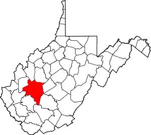
| State | West Virginia |
| County | Kanawha |
| Elevation | 889 ft (271 m) |
| Time zone | UTC-5 (Eastern (EST)) |
| • Summer (DST) | UTC-4 (EDT) |
| Area code(s) | 304 & 681 |
| GNIS feature ID | 1536771[1] |
Burnwell is an unincorporated community in Kanawha County, West Virginia, United States. Burnwell is 10.5 miles (16.9 km) east-northeast of Sylvester.
The community originally was a coal-mining community, hence the name Burnwell.[2]
References
- ↑ "US Board on Geographic Names". United States Geological Survey. October 25, 2007. Retrieved January 31, 2008.
- ↑ Kenny, Hamill (1945). West Virginia Place Names: Their Origin and Meaning, Including the Nomenclature of the Streams and Mountains. Piedmont, WV: The Place Name Press. p. 144.
This article is issued from Wikipedia. The text is licensed under Creative Commons - Attribution - Sharealike. Additional terms may apply for the media files.