Dickinson, West Virginia | |
|---|---|
 Dickinson  Dickinson | |
| Coordinates: 38°12′13″N 81°30′09″W / 38.20361°N 81.50250°W | |
| Country | United States |
| State | West Virginia |
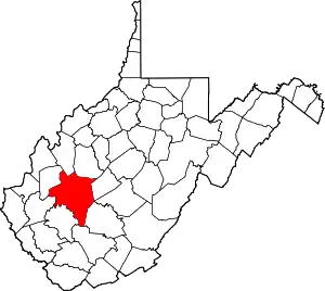
| County | Kanawha |
| Elevation | 630 ft (190 m) |
| Time zone | UTC-5 (Eastern (EST)) |
| • Summer (DST) | UTC-4 (EDT) |
| Area code(s) | 304 & 681 |
| GNIS feature ID | 1550920[1] |
Dickinson, also known as Quincy, is an unincorporated community in Kanawha County, West Virginia, United States. Dickinson is located on the north bank of the Kanawha River, 3 miles (4.8 km) southeast of Belle. The community is served by U.S. Route 60.[2]
The community was named after John Quincy Dickinson, the original owner of the town site.[3]
References
- ↑ U.S. Geological Survey Geographic Names Information System: Dickinson, West Virginia
- ↑ Kanawha County General Highway Map (PDF) (Map). West Virginia Department of Transportation. 2008. § 4. Retrieved August 8, 2010.
- ↑ Kenny, Hamill (1945). West Virginia Place Names: Their Origin and Meaning, Including the Nomenclature of the Streams and Mountains. Piedmont, WV: The Place Name Press. p. 515.
This article is issued from Wikipedia. The text is licensed under Creative Commons - Attribution - Sharealike. Additional terms may apply for the media files.