Hugheston, West Virginia | |
|---|---|
 Hugheston  Hugheston | |
| Coordinates: 38°12′34″N 81°22′21″W / 38.20944°N 81.37250°W | |
| Country | United States |
| State | West Virginia |
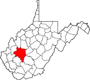
| County | Kanawha |
| Area | |
| • Total | 15.4 sq mi (40 km2) |
| • Land | 15.4 sq mi (40 km2) |
| • Water | 0 sq mi (0 km2) |
| Elevation | 636 ft (194 m) |
| Population | |
| • Total | 569 |
| • Density | 36.95/sq mi (14.27/km2) |
| Time zone | UTC-5 (Eastern (EST)) |
| • Summer (DST) | UTC-4 (EDT) |
| ZIP code | 25110 |
| Area code(s) | 304 & 681 |
| GNIS feature ID | 1554756[3] |
Hugheston is an unincorporated community in Kanawha County, West Virginia, United States. Hugheston is located on the north bank of the Kanawha River across from Pratt. Hugheston has a post office with ZIP code 25110.[4] The average household income is $32,436.[2]
The community most likely derives its name from Robert Hughes, a local pioneer who was kidnapped by Indians.[5]
Historian and noted author Otis K. Rice was born in Hugheston on June 6, 1919. Rice was named West Virginia’s first Historian Laureate in 2003.[6]
References
- 1 2 "Hugheston, WV 25110". Retrieved June 19, 2010.
- 1 2 "MCDC Demographic Profile 3, 2000 Census - HUGHESTON (Mo Census Data Center)". Archived from the original on August 27, 2014. Retrieved June 19, 2010.
- ↑ "US Board on Geographic Names". United States Geological Survey. October 25, 2007. Retrieved January 31, 2008.
- ↑ ZIP Code Lookup
- ↑ Kenny, Hamill (1945). West Virginia Place Names: Their Origin and Meaning, Including the Nomenclature of the Streams and Mountains. Piedmont, WV: The Place Name Press. p. 316.
- ↑ "e-WV | The West Virginia Encyclopedia". www.wvencyclopedia.org. Retrieved September 30, 2021.
This article is issued from Wikipedia. The text is licensed under Creative Commons - Attribution - Sharealike. Additional terms may apply for the media files.