Conteville-en-Ternois | |
|---|---|
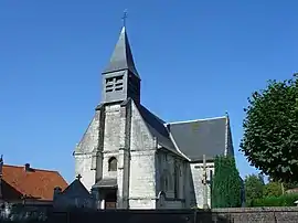 The church of Conteville-en-Ternois | |
 Coat of arms | |
Location of Conteville-en-Ternois | |
 Conteville-en-Ternois  Conteville-en-Ternois | |
| Coordinates: 50°25′58″N 2°19′30″E / 50.4328°N 2.325°E | |
| Country | France |
| Region | Hauts-de-France |
| Department | Pas-de-Calais |
| Arrondissement | Arras |
| Canton | Saint-Pol-sur-Ternoise |
| Intercommunality | CC Ternois |
| Government | |
| • Mayor (2020–2026) | Jean-Claude Habert[1] |
| Area 1 | 2.29 km2 (0.88 sq mi) |
| Population | 79 |
| • Density | 34/km2 (89/sq mi) |
| Time zone | UTC+01:00 (CET) |
| • Summer (DST) | UTC+02:00 (CEST) |
| INSEE/Postal code | 62238 /62130 |
| Elevation | 85–156 m (279–512 ft) (avg. 147 m or 482 ft) |
| 1 French Land Register data, which excludes lakes, ponds, glaciers > 1 km2 (0.386 sq mi or 247 acres) and river estuaries. | |
Conteville-en-Ternois is a commune in the Pas-de-Calais department in the Hauts-de-France region of France.[3]
Geography
A small farming village located 21 miles (34 km) northwest of Arras on the D88 road.
Population
| Year | Pop. | ±% p.a. |
|---|---|---|
| 1968 | 118 | — |
| 1975 | 84 | −4.74% |
| 1982 | 74 | −1.79% |
| 1990 | 73 | −0.17% |
| 1999 | 69 | −0.62% |
| 2007 | 79 | +1.71% |
| 2012 | 88 | +2.18% |
| 2017 | 91 | +0.67% |
| Source: INSEE[4] | ||
Places of interest
- The church of St.Nicaise, dating from the fourteenth century.
- The chateau.
See also
References
- ↑ "Répertoire national des élus: les maires". data.gouv.fr, Plateforme ouverte des données publiques françaises (in French). 2 December 2020.
- ↑ "Populations légales 2021". The National Institute of Statistics and Economic Studies. 28 December 2023.
- ↑ INSEE commune file
- ↑ Population en historique depuis 1968, INSEE
Wikimedia Commons has media related to Conteville-en-Ternois.
This article is issued from Wikipedia. The text is licensed under Creative Commons - Attribution - Sharealike. Additional terms may apply for the media files.