Saint-Étienne-au-Mont
Sint-Stevens Bergen | |
|---|---|
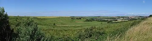
 The route to Ecault beach | |
 Coat of arms | |
Location of Saint-Étienne-au-Mont | |
 Saint-Étienne-au-Mont  Saint-Étienne-au-Mont | |
| Coordinates: 50°40′56″N 1°37′37″E / 50.6822°N 1.6269°E | |
| Country | France |
| Region | Hauts-de-France |
| Department | Pas-de-Calais |
| Arrondissement | Boulogne-sur-Mer |
| Canton | Outreau |
| Intercommunality | CA Boulonnais |
| Government | |
| • Mayor (2020–2026) | Brigitte Passebosc[1] |
| Area 1 | 14.05 km2 (5.42 sq mi) |
| Population | 5,072 |
| • Density | 360/km2 (930/sq mi) |
| Time zone | UTC+01:00 (CET) |
| • Summer (DST) | UTC+02:00 (CEST) |
| INSEE/Postal code | 62746 /62360 |
| Elevation | 3–113 m (9.8–370.7 ft) (avg. 7 m or 23 ft) |
| 1 French Land Register data, which excludes lakes, ponds, glaciers > 1 km2 (0.386 sq mi or 247 acres) and river estuaries. | |
Saint-Étienne-au-Mont (French pronunciation: [sɛ̃t‿etjɛn‿o mɔ̃]; Picard: Sant-Étienne-au-Mont; obsolete Dutch: Sint-Stevensbergen, lit. 'St. Stephen's Mountains') is a commune in the Pas-de-Calais department in the Hauts-de-France region of France near Boulogne-sur-Mer.[3] Besides the main settlement Saint-Étienne-au-Mont, the commune consists of the two smaller settlements Pont-de-Briques and Écault.
Geography
Saint-Étienne-au-Mont is a small farming and light industrial town situated some 3 miles (4.8 km) south of Boulogne, at the junction of the D52 and D940 roads. The Liane river flows from the north of the commune to the south-east. Beyond Écault lies the English Channel (in the west).
Population
| Year | Pop. | ±% p.a. |
|---|---|---|
| 1968 | 4,389 | — |
| 1975 | 4,301 | −0.29% |
| 1982 | 4,632 | +1.06% |
| 1990 | 5,037 | +1.05% |
| 1999 | 4,995 | −0.09% |
| 2007 | 5,068 | +0.18% |
| 2012 | 5,097 | +0.11% |
| 2017 | 5,076 | −0.08% |
| Source: INSEE[4] | ||
Places of interest


- The church of Sainte-Thérèse, a nineteenth century church.[5]
- The St. Etienne-au-Mont Communal Cemetery (including the Commonwealth War Graves Commission cemetery)[6] created during World War I for men of the Chinese Labour Corps and of the South African Native Labour Corps.
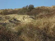
- The sand dunes along the beach and Aréna (a centre in Écault dedicated to the world of dunes).
- The Château d'Audisque, dating from the eighteenth century and a registered monument.[7]
- The Pont-de-Briques, a bridge across the Liane
- The view from the Chapelle d'Écault (the church is also known as l'Église de Saint-Étienne and dates from the twelfth century)
Hiking
To get a good idea of the area you can walk the Sentier de la Converserie.[8] The name is derived from the Converserie, a building on the site of a former leper colony. It encompasses Le Chemin des Juifs[9] and passes Aréna and the Château d'Hardelot (now the Centre Franco-brittanique de l'Entente Cordiale[10]) as well as the local cemetery (which contains de CWGC cemetery).
See also
References
- ↑ "Répertoire national des élus: les maires" (in French). data.gouv.fr, Plateforme ouverte des données publiques françaises. 13 September 2022.
- ↑ "Populations légales 2021". The National Institute of Statistics and Economic Studies. 28 December 2023.
- ↑ INSEE commune file
- ↑ Population en historique depuis 1968, INSEE
- ↑ Base Mérimée: Eglise paroissiale Sainte-Thérèse, Ministère français de la Culture. (in French)
- ↑ The CWGC cemetery at St. Etienne-au-Mont
- ↑ Base Mérimée: Château d'Audisque, Ministère français de la Culture. (in French)
- ↑ Leaflet describing the route on the Boulonnais website
- ↑ The Way of the Jews on the Saint-Etienne-au-Mont website
- ↑ The Château d'Hardelot website