Feketeerdő | |
|---|---|
 Flag  Coat of arms | |
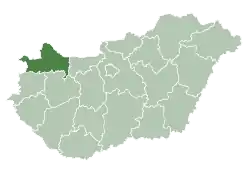
 Feketeerdő Location of Feketeerdő | |
| Coordinates: 47°56′07″N 17°16′42″E / 47.93533°N 17.27828°E | |
| Country | |
| County | Győr-Moson-Sopron |
| Area | |
| • Total | 6.74 km2 (2.60 sq mi) |
| Population (2004) | |
| • Total | 433 |
| • Density | 64.24/km2 (166.4/sq mi) |
| Time zone | UTC+1 (CET) |
| • Summer (DST) | UTC+2 (CEST) |
| Postal code | 9211 |
| Area code | 96 |
Feketeerdő (German: Schwarzwald) is a village in Győr-Moson-Sopron county, Hungary. It lies near Mosonmagyaróvár and is close to both the Austrian and Slovakian borders.
External links
- Street map (in Hungarian)
This article is issued from Wikipedia. The text is licensed under Creative Commons - Attribution - Sharealike. Additional terms may apply for the media files.