Győrújbarát | |
|---|---|
 Flag  Coat of arms | |
 Győrújbarát Location of Győrújbarát | |
| Coordinates: 47°36′28″N 17°38′47″E / 47.60790°N 17.64636°E | |
| Country | |
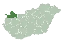
| County | Győr-Moson-Sopron |
| Area | |
| • Total | 33.68 km2 (13.00 sq mi) |
| Population (2018) | |
| • Total | 7,587 |
| • Density | 230/km2 (580/sq mi) |
| Time zone | UTC+1 (CET) |
| • Summer (DST) | UTC+2 (CEST) |
| Postal code | 9081 |
| Area code | 96 |
| Motorways | M1 |
| Distance from Budapest | 125 km (78 mi) East |
Győrújbarát is a village near Győr in Győr-Moson-Sopron county, Hungary.
External links
- Street map (in Hungarian)
| City with county rights (1) |
| |
|---|---|---|
| Villages (34) |
| |

This article is issued from Wikipedia. The text is licensed under Creative Commons - Attribution - Sharealike. Additional terms may apply for the media files.