Hope Bay Aerodrome | |||||||||||
|---|---|---|---|---|---|---|---|---|---|---|---|
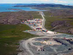 On approach to the runway | |||||||||||
| Summary | |||||||||||
| Airport type | Private | ||||||||||
| Operator | Agnico Eagle Mines Limited | ||||||||||
| Time zone | MST (UTC−07:00) | ||||||||||
| • Summer (DST) | MDT (UTC−06:00) | ||||||||||
| Elevation AMSL | 155 ft / 47 m | ||||||||||
| Coordinates | 68°09′40″N 106°36′56″W / 68.16111°N 106.61556°W | ||||||||||
| Map | |||||||||||
 CHB3  CHB3 | |||||||||||
| Runways | |||||||||||
| |||||||||||
Source: Canada Flight Supplement[1] | |||||||||||
Hope Bay Aerodrome (IATA: UZM, TC LID: CHB3) is an aerodrome located near Hope Bay, in the western Kitikmeot Region of Nunavut, Canada. The runway serves Hope Bay Mine site and the gold exploration camps in the area.
Airlines and destinations
| Airlines | Destinations |
|---|---|
| Canadian North | Charter: Cambridge Bay, Yellowknife |
Hope Bay Mine
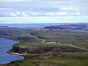 View of Hope Bay from the south
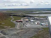 Main Camp
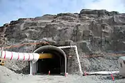 Mine shaft has now been sealed
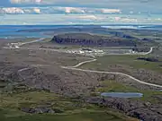 Broad view of Hope Bay
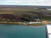 First camp site
See also
References
External links
Wikimedia Commons has media related to Hope Bay Gold Mine.
- Past three hours METARs, SPECI and current TAFs for Hope Bay Aerodrome from Nav Canada as available.
| By name | |
|---|---|
| By location indicator | |
| By province/territory | |
| By area | |
| National Airports System | |
| Related | |
| |
This article is issued from Wikipedia. The text is licensed under Creative Commons - Attribution - Sharealike. Additional terms may apply for the media files.