Saint-Étienne-de-Chomeil | |
|---|---|
 The Château of Saint-Étienne, in Saint-Étienne-de-Chomeil | |
.svg.png.webp) Coat of arms | |
Location of Saint-Étienne-de-Chomeil | |
 Saint-Étienne-de-Chomeil  Saint-Étienne-de-Chomeil | |
| Coordinates: 45°20′38″N 2°36′12″E / 45.3439°N 2.6033°E | |
| Country | France |
| Region | Auvergne-Rhône-Alpes |
| Department | Cantal |
| Arrondissement | Mauriac |
| Canton | Riom-ès-Montagnes |
| Government | |
| • Mayor (2020–2026) | Gilbert Mommalier[1] |
| Area 1 | 27.57 km2 (10.64 sq mi) |
| Population | 249 |
| • Density | 9.0/km2 (23/sq mi) |
| Time zone | UTC+01:00 (CET) |
| • Summer (DST) | UTC+02:00 (CEST) |
| INSEE/Postal code | 15185 /15400 |
| Elevation | 500–981 m (1,640–3,219 ft) (avg. 700 m or 2,300 ft) |
| 1 French Land Register data, which excludes lakes, ponds, glaciers > 1 km2 (0.386 sq mi or 247 acres) and river estuaries. | |
Saint-Étienne-de-Chomeil (French pronunciation: [sɛ̃.t‿etjɛn də ʃɔmɛj]; Auvergnat: Sent Estèfe de Chaumelh) is a commune in the Cantal department in south-central France. It belongs to the Parc Naturel Régional des Volcans d'Auvergne.
Geography
The river Rhue forms all of the commune's northern border.
Population
| Year | Pop. | ±% |
|---|---|---|
| 1962 | 390 | — |
| 1968 | 505 | +29.5% |
| 1975 | 442 | −12.5% |
| 1982 | 378 | −14.5% |
| 1990 | 310 | −18.0% |
| 1999 | 259 | −16.5% |
| 2008 | 213 | −17.8% |
| 2016 | 215 | +0.9% |
Sites of interest
- The Church
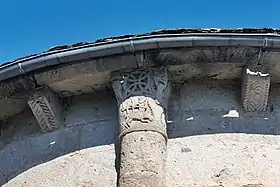
Dedicated to Saint-Étienne — French for Saint Stephen — this church takes elements from both Roman and Gothic architectures. Built during the 11th and 12th centuries, it is a Monument Historique since 1993. One of its most characteristic features is its south-west capital, supporting a Sagittarius and two faces, one of which — the right one on the picture below — features an enormous tongue.
- The Castle
Saint-Étienne's castle was built during the 14th century, then heavily modified from the 17th century onwards.
- Rocher d'Urlande (Rock of Urlande)
Witness of the volcanic history of the department, the Rocher d'Urlande is now a renowned rock-climbing site.
See also
References
- ↑ "Répertoire national des élus: les maires". data.gouv.fr, Plateforme ouverte des données publiques françaises (in French). 9 August 2021.
- ↑ "Populations légales 2021". The National Institute of Statistics and Economic Studies. 28 December 2023.