Saint-Andéol | |
|---|---|
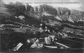 Saint-Andéol in the early 20th century | |
Location of Saint-Andéol | |
 Saint-Andéol  Saint-Andéol | |
| Coordinates: 44°57′43″N 5°33′11″E / 44.9619°N 5.5531°E | |
| Country | France |
| Region | Auvergne-Rhône-Alpes |
| Department | Isère |
| Arrondissement | Grenoble |
| Canton | Matheysine-Trièves |
| Government | |
| • Mayor (2020–2026) | Gilles Cleret[1] |
| Area 1 | 30 km2 (10 sq mi) |
| Population | 121 |
| • Density | 4.0/km2 (10/sq mi) |
| Time zone | UTC+01:00 (CET) |
| • Summer (DST) | UTC+02:00 (CEST) |
| INSEE/Postal code | 38355 /38650 |
| Elevation | 792–2,087 m (2,598–6,847 ft) |
| 1 French Land Register data, which excludes lakes, ponds, glaciers > 1 km2 (0.386 sq mi or 247 acres) and river estuaries. | |
Saint-Andéol (French pronunciation: [sɛ̃.t‿ɑ̃deɔl]) is a commune in the Isère department in southeastern France.[3]
Population
| Year | Pop. | ±% p.a. |
|---|---|---|
| 1968 | 53 | — |
| 1975 | 68 | +3.62% |
| 1982 | 66 | −0.43% |
| 1990 | 92 | +4.24% |
| 1999 | 123 | +3.28% |
| 2009 | 110 | −1.11% |
| 2014 | 126 | +2.75% |
| 2020 | 123 | −0.40% |
| Source: INSEE[4] | ||
See also
References
Wikimedia Commons has media related to Saint-Andéol (Isère).
- ↑ "Répertoire national des élus: les maires" (in French). data.gouv.fr, Plateforme ouverte des données publiques françaises. 13 September 2022.
- ↑ "Populations légales 2021". The National Institute of Statistics and Economic Studies. 28 December 2023.
- ↑ INSEE commune file
- ↑ Population en historique depuis 1968, INSEE
This article is issued from Wikipedia. The text is licensed under Creative Commons - Attribution - Sharealike. Additional terms may apply for the media files.