Sermérieu | |
|---|---|
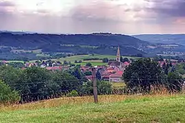 A general view of Sermérieu | |
Location of Sermérieu | |
 Sermérieu  Sermérieu | |
| Coordinates: 45°40′20″N 5°24′36″E / 45.6722°N 5.41°E | |
| Country | France |
| Region | Auvergne-Rhône-Alpes |
| Department | Isère |
| Arrondissement | La Tour-du-Pin |
| Canton | Morestel |
| Government | |
| • Mayor (2020–2026) | Alexandre Bolleau[1] |
| Area 1 | 17.14 km2 (6.62 sq mi) |
| Population | 1,644 |
| • Density | 96/km2 (250/sq mi) |
| Time zone | UTC+01:00 (CET) |
| • Summer (DST) | UTC+02:00 (CEST) |
| INSEE/Postal code | 38483 /38510 |
| Elevation | 223–385 m (732–1,263 ft) (avg. 298 m or 978 ft) |
| 1 French Land Register data, which excludes lakes, ponds, glaciers > 1 km2 (0.386 sq mi or 247 acres) and river estuaries. | |
Sermérieu (French pronunciation: [sɛʁmeʁjø]) is a commune in the Isère department in southeastern France.[3]
Population
| Year | Pop. | ±% p.a. |
|---|---|---|
| 1968 | 639 | — |
| 1975 | 588 | −1.18% |
| 1982 | 756 | +3.66% |
| 1990 | 935 | +2.69% |
| 1999 | 1,168 | +2.50% |
| 2009 | 1,482 | +2.41% |
| 2014 | 1,591 | +1.43% |
| 2020 | 1,654 | +0.65% |
| Source: INSEE[4] | ||
See also
References
- ↑ "Répertoire national des élus: les maires". data.gouv.fr, Plateforme ouverte des données publiques françaises (in French). 2 December 2020.
- ↑ "Populations légales 2021". The National Institute of Statistics and Economic Studies. 28 December 2023.
- ↑ INSEE commune file
- ↑ Population en historique depuis 1968, INSEE
Wikimedia Commons has media related to Sermérieu.
This article is issued from Wikipedia. The text is licensed under Creative Commons - Attribution - Sharealike. Additional terms may apply for the media files.